ForeFlight Mobile EFB 16.3.1
Free Version
Publisher Description
ForeFlight delivers advanced flight planning capabilities, terminal procedure charts, enroute navigation charts, moving map, synthetic vision, hazard awareness, optional Jeppesen charts, a comprehensive library of market-leading weather information and visualization features, a large library of advanced aircraft performance profiles, customizable checklists, integration with a wide range of certified avionics and portable ADS-B and GPS receivers for inflight weather and data, a built-in documents catalog and cloud document capability for management of aircraft and flight operations publications, an easy-to-use pilot logbook for keeping track of flight experience, and so much more. ForeFlight is backed by our Pilot Support Team who delivers amazingly fast, accurate, and friendly customer service.
Please note: Location is used to enable a moving map and to record track logs, the camera is used to attach photos to logbook, push notifications are used for important bulletins and flight alerts, and contacts are used to add people to flights.
ForeFlight requires a subscription. Visit our website for more information on the available plan levels.
FLIGHT PLANNING, BRIEFING, & FILING
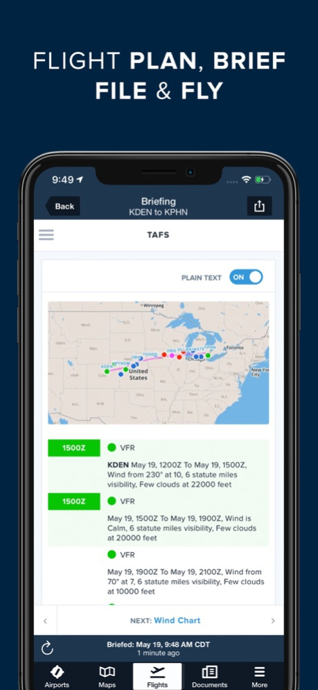
Plan flights with Touch Planning on the Map or full-featured form-based Flights view. Tap out a route in seconds and quickly see if flights will be affected by weather or TFRs. Helpful Route, Altitude, and Procedure Advisors make planning easy and accurate. Generate a graphical preflight briefing and file your flight plan directly from the app. Print a professional-grade Navlog for inflight reference.
WEATHER
Interactive weather layers include animated radar, global satellite and winds aloft, global icing, turbulence, and surface analysis, graphical AIR/SIGMETs, flight category, visibility, and more. View decoded METARs, TAFs, and MOS forecasts. Thoughtfully organized Imagery view puts a full range of forecast tools at your fingertips.
PLATES, CHARTS, & MAPS
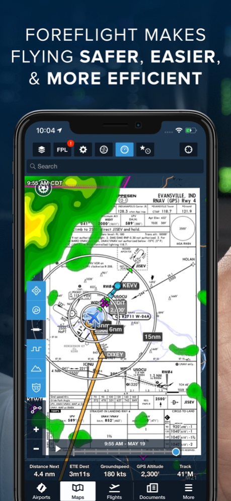
Both VFR and IFR operations are covered with all of the essentials required for planning and navigation: data-driven Aeronautical Maps, VFR Sectionals, High/Low Enroute charts, SIDs, STARs, approach and taxi charts, and terrain, satellite, and street map views.
GEO-REFERENCED APPROACHES & TAXI CHARTS
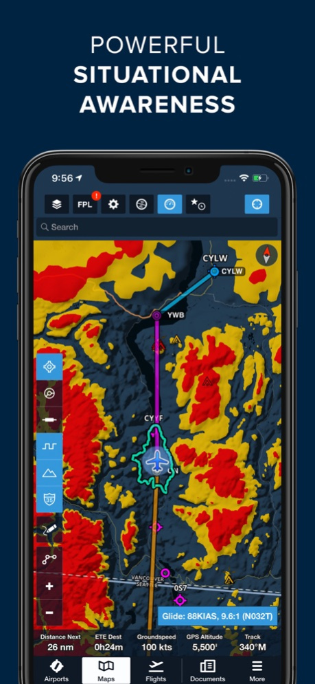
Plates and taxi charts enable the real time display of your GPS location on the chart. They can also be overlaid on the Maps view along with weather and hazards for the ultimate situational awareness.
GLOBAL HAZARD AWARENESS TECHNOLOGY
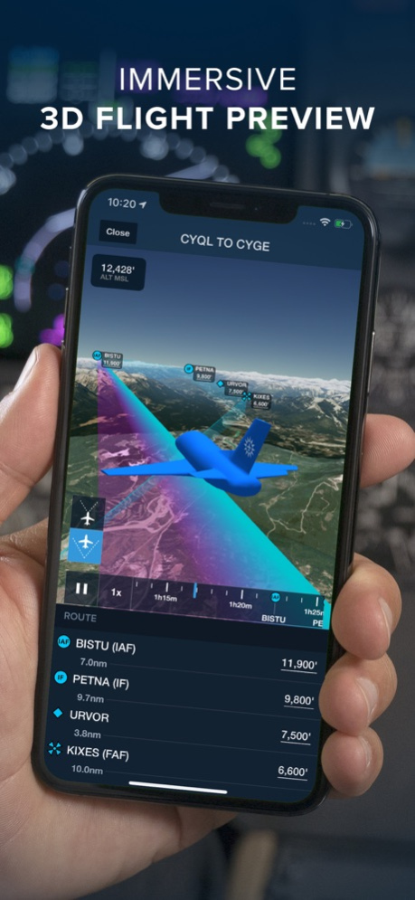
Plan and fly with more confidence in all conditions and terrain. Top-down-view Hazard Advisor map layer, Terrain Profile View, and 3D Synthetic Vision seamlessly integrate into the map display to depict a clear picture of terrain and obstacle hazards anywhere in the world. When paired with an AHRS source, Synthetic Vision provides a backup attitude display.
LOGBOOK
Logbook makes it easy to log and share flights, track hours, review currency, record certificates and ratings, receive electronic instructor endorsements, and create experience reports. Your data is automatically synced across all your devices and protected in secure cloud storage.
ADDITIONAL FEATURES INCLUDE:
Built-in documents catalog with FAR/AIM, charts supplements, and more
Airport, FBO, and fuel price information for thousands of locations
Dynamic data-driven Aeronautical Maps
Weight & Balance
Glide Advisor
Expected route and EDCT flight notifications
Automatic over-the-air data updates
Chart color inversion for better night flying experience
Access to web planner
REVIEWS
Flying Magazine Editor's Choice 2012, 2013, 2014, 2017
App of the Year, Aviation Consumer, July 2011
Best Selling iPad Aviation App: 2010, 2011, 2012
"Best app for IFR" - Aviation Consumer
"One of the most popular and most-respected aviation apps available" - Sporty's Pilot Shop
Mar 28, 2024
Version 16.3.1
Aeronautical Map Drawer
• A consolidated drawer now houses all Aeronautical Map toggles and settings, optimizing space when you aren’t using it.
• Tap the new button in the lower-left corner of the Maps view with the Aeronautical Map layer enabled to open the drawer and toggle map elements like airports, airspace, waypoints, airways, terrain, and more, or tap the ellipses button at the very bottom to access Aeronautical Map Settings.
• Below the toggles are new Aeronautical Modes for IFR High, IFR Low, and VFR, which you can select to quickly change altitude-based map elements like waypoints, navaids, airways, ATC boundaries, and VFR map elements.
• Any changes you make to the quick toggles or settings only apply to the currently selected Aeronautical Mode, so you can configure each mode with separate toggle selections and settings and change all of them at once just by switching modes.
• The Aeronautical Map Drawer will automatically close after a period of inactivity - 10 seconds by default. You can increase or decrease this time using the “Auto-Dismiss After” setting at the top of the Aeronautical Map Settings menu. You can also tap anywhere on the map to close the drawer.
Basic Navlog Template
• Tailored for VFR pilots, the new Basic Navlog offers a cleaner format resembling a traditional navlog.
• From the Flights view, tap the Navlog button next to Briefing at the top of a flight plan to open the Navlog, then tap the Settings cog in the top-right to select the Basic template.
• The Basic Navlog also has better print quality compared to the other Navlog formats, especially when using half-sheet printing.
Power Lines on Basemap
• Plan and fly with global power line depictions on ForeFlight's high-resolution Basemap for enhanced hazard awareness.
• Power lines are depicted on the map in a distinct maroon color, presented as lines with hash marks for easy identification.
Sentry Allows Cellular Data
• Access internet data in ForeFlight via your device’s cellular connection even while connected to any Sentry-family ADS-B receiver to check internet-sourced radar, amend a flight plan prior to takeoff, and more.
• Internet-based map layers will remain selectable while connected to Sentry so you can easily jump between them and live ADS-B weather while receiving cellular data.
New Airspace Settings
• Tailor the display of airspace on ForeFlight's Aeronautical Map with global Class E airspace filtering and more granular control over different types of Special Use Airspace.
• Previously only applied to US airspace, the Class E toggle now shows or hides Class E airspace globally. This toggle has also been grouped with TRSA and Mode C toggles in the Controlled Airspace section of the Aeronautical Map Settings menu.
• The new Special Use Airspace section of the Settings menu combines existing toggles for Parachute Areas and ADIZ with new, more granular toggles: "Prohibited & Restricted," "MOA, Alert, and Training," "Caution, Danger, & Warning," "TRA & TSA," and "Other."
• Access these and other airspace settings via the Settings button at the bottom of the new Aeronautical Map Drawer.
Southern Africa VFR Charts
• Detailed VFR charts providing comprehensive local airspace details are now accessible for several countries across southern Africa: Angola, Botswana, Eswatini, Lesotho, Mozambique, Namibia, South Africa, Zambia, and Zimbabwe.
About ForeFlight Mobile EFB
ForeFlight Mobile EFB is a free app for iOS published in the Astronomy list of apps, part of Home & Hobby.
The company that develops ForeFlight Mobile EFB is ForeFlight. The latest version released by its developer is 16.3.1. This app was rated by 8 users of our site and has an average rating of 3.3.
To install ForeFlight Mobile EFB on your iOS device, just click the green Continue To App button above to start the installation process. The app is listed on our website since 2024-03-28 and was downloaded 864 times. We have already checked if the download link is safe, however for your own protection we recommend that you scan the downloaded app with your antivirus. Your antivirus may detect the ForeFlight Mobile EFB as malware if the download link is broken.
How to install ForeFlight Mobile EFB on your iOS device:
- Click on the Continue To App button on our website. This will redirect you to the App Store.
- Once the ForeFlight Mobile EFB is shown in the iTunes listing of your iOS device, you can start its download and installation. Tap on the GET button to the right of the app to start downloading it.
- If you are not logged-in the iOS appstore app, you'll be prompted for your your Apple ID and/or password.
- After ForeFlight Mobile EFB is downloaded, you'll see an INSTALL button to the right. Tap on it to start the actual installation of the iOS app.
- Once installation is finished you can tap on the OPEN button to start it. Its icon will also be added to your device home screen.
Program Details
General |
|
|---|---|
| Publisher | ForeFlight |
| Released Date | 2024-03-28 |
| Languages | English |
Category |
|
|---|---|
| Category | Home & Hobby |
| Subcategory | Astronomy |
System requirements |
|
|---|---|
| Operating systems | ios |
Download information |
|
|---|---|
| File size | 452.88 MB |
| Total downloads | 864 |
Pricing |
|
|---|---|
| License model | Free |
| Price | N/A |
Version History
version 16.3.1
posted on 2024-03-28
Mar 28, 2024
Version 16.3.1
Aeronautical Map Drawer
• A consolidated drawer now houses all Aeronautical Map toggles and settings, optimizing space when you aren’t using it.
• Tap the new button in the lower-left corner of the Maps view with the Aeronautical Map layer enabled to open the drawer and toggle map elements like airports, airspace, waypoints, airways, terrain, and more, or tap the ellipses button at the very bottom to access Aeronautical Map Settings.
• Below the toggles are new Aeronautical Modes for IFR High, IFR Low, and VFR, which you can select to quickly change altitude-based map elements like waypoints, navaids, airways, ATC boundaries, and VFR map elements.
• Any changes you make to the quick toggles or settings only apply to the currently selected Aeronautical Mode, so you can configure each mode with separate toggle selections and settings and change all of them at once just by switching modes.
• The Aeronautical Map Drawer will automatically close after a period of inactivity - 10 seconds by default. You can increase or decrease this time using the “Auto-Dismiss After” setting at the top of the Aeronautical Map Settings menu. You can also tap anywhere on the map to close the drawer.
Basic Navlog Template
• Tailored for VFR pilots, the new Basic Navlog offers a cleaner format resembling a traditional navlog.
• From the Flights view, tap the Navlog button next to Briefing at the top of a flight plan to open the Navlog, then tap the Settings cog in the top-right to select the Basic template.
• The Basic Navlog also has better print quality compared to the other Navlog formats, especially when using half-sheet printing.
Power Lines on Basemap
• Plan and fly with global power line depictions on ForeFlight's high-resolution Basemap for enhanced hazard awareness.
• Power lines are depicted on the map in a distinct maroon color, presented as lines with hash marks for easy identification.
• The Basemap is usually paired with the Aeronautical Map and can be seen by turning off other chart layers that cover it. Download the high-resolution basempa for other regions in More > Downloads > Data Settings.
Sentry Allows Cellular Data
• Access internet data in ForeFlight via your device’s cellular connection even while connected to any Sentry-family ADS-B receiver to check internet-sourced radar, amend a flight plan prior to takeoff, and more.
• Internet-based map layers will remain selectable while connected to Sentry so you can easily jump between them and live ADS-B weather while receiving cellular data.
New Airspace Settings
• Tailor the display of airspace on ForeFlight's Aeronautical Map with global Class E airspace filtering and more granular control over different types of Special Use Airspace.
• Previously only applied to US airspace, the Class E toggle now shows or hides Class E airspace globally. This toggle has also been grouped with TRSA and Mode C toggles in the Controlled Airspace section of the Aeronautical Map Settings menu.
• The new Special Use Airspace section of the Settings menu combines existing toggles for Parachute Areas and ADIZ with new, more granular toggles: "Prohibited & Restricted," "MOA, Alert, and Training," "Caution, Danger, & Warning," "TRA & TSA," and "Other."
• Access these and other airspace settings via the Settings button at the bottom of the new Aeronautical Map Drawer.
Southern Africa VFR Charts
• Detailed VFR charts providing comprehensive local airspace details are now accessible for several countries across southern Africa: Angola, Botswana, Eswatini, Lesotho, Mozambique, Namibia, South Africa, Zambia, and Zimbabwe.
• You can add this region to your ForeFlight subscription via the ForeFlight website and select countries in More > Downloads > Region Settings to download charts.
version 16.3
posted on 2024-03-26
Mar 26, 2024
Version 16.3
Aeronautical Map Drawer
• A consolidated drawer now houses all Aeronautical Map toggles and settings, optimizing space when you aren’t using it.
• Tap the new button in the lower-left corner of the Maps view with the Aeronautical Map layer enabled to open the drawer and toggle map elements like airports, airspace, waypoints, airways, terrain, and more, or tap the ellipses button at the very bottom to access Aeronautical Map Settings.
• Below the toggles are new Aeronautical Modes for IFR High, IFR Low, and VFR, which you can select to quickly change altitude-based map elements like waypoints, navaids, airways, ATC boundaries, and VFR map elements.
• Any changes you make to the quick toggles or settings only apply to the currently selected Aeronautical Mode, so you can configure each mode with separate toggle selections and settings and change all of them at once just by switching modes.
• The Aeronautical Map Drawer will automatically close after a period of inactivity - 10 seconds by default. You can increase or decrease this time using the “Auto-Dismiss After” setting at the top of the Aeronautical Map Settings menu. You can also tap anywhere on the map to close the drawer.
Basic Navlog Template
• Tailored for VFR pilots, the new Basic Navlog offers a cleaner format resembling a traditional navlog.
• From the Flights view, tap the Navlog button next to Briefing at the top of a flight plan to open the Navlog, then tap the Settings cog in the top-right to select the Basic template.
• The Basic Navlog also has better print quality compared to the other Navlog formats, especially when using half-sheet printing.
Power Lines on Basemap
• Plan and fly with global power line depictions on ForeFlight's high-resolution Basemap for enhanced hazard awareness.
• Power lines are depicted on the map in a distinct maroon color, presented as lines with hash marks for easy identification.
• The Basemap is usually paired with the Aeronautical Map and can be seen by turning off other chart layers that cover it. Download the high-resolution basempa for other regions in More > Downloads > Data Settings.
Sentry Allows Cellular Data
• Access internet data in ForeFlight via your device’s cellular connection even while connected to any Sentry-family ADS-B receiver to check internet-sourced radar, amend a flight plan prior to takeoff, and more.
• Internet-based map layers will remain selectable while connected to Sentry so you can easily jump between them and live ADS-B weather while receiving cellular data.
New Airspace Settings
• Tailor the display of airspace on ForeFlight's Aeronautical Map with global Class E airspace filtering and more granular control over different types of Special Use Airspace.
• Previously only applied to US airspace, the Class E toggle now shows or hides Class E airspace globally. This toggle has also been grouped with TRSA and Mode C toggles in the Controlled Airspace section of the Aeronautical Map Settings menu.
• The new Special Use Airspace section of the Settings menu combines existing toggles for Parachute Areas and ADIZ with new, more granular toggles: "Prohibited & Restricted," "MOA, Alert, and Training," "Caution, Danger, & Warning," "TRA & TSA," and "Other."
• Access these and other airspace settings via the Settings button at the bottom of the new Aeronautical Map Drawer.
Southern Africa VFR Charts
• Detailed VFR charts providing comprehensive local airspace details are now accessible for several countries across southern Africa: Angola, Botswana, Eswatini, Lesotho, Mozambique, Namibia, South Africa, Zambia, and Zimbabwe.
• You can add this region to your ForeFlight subscription via the ForeFlight website and select countries in More > Downloads > Region Settings to download charts.
version 16.2.1
posted on 2024-03-04
Mar 4, 2024
Version 16.2.1
MORA/LSALT Grid Overlay
• Identify the altitudes to avoid along your flight route by referencing the Minimum Off-Route Altitude (MORA), or Lowest Safe Altitude (LSALT) in Australia, directly on the map.
• Altitudes, in feet, are represented as the first number indicating thousands and the second, smaller number indicating hundreds within the grid.
• The grid initially is presented as a 5ºx5º grid, which dynamically condenses to 1ºx1º as you zoom in on the map.
• Altitudes under 10,000 feet are depicted in green, suggesting lower terrain/obstacle heights, while altitudes exceeding 10,000 feet are highlighted in red, indicating significantly higher terrain/obstacles.
• This new setting is enabled by default but can be disabled in Map Settings > Grid MORA/LSALT (ft) while the Aeronautical Map is active.
Logbook: Preview Student Comments
• Instructors can now review student comments prior to signing remote entries, ensuring transparency and efficiency. Easily append notes, sign, and save without hassle.
• New signature requests appear in Logbook > Drafts & Requests with a preview of the student’s comments.
• In addition to existing functionalities, instructors can now save the draft along with student comments to their personal logbook. This ensures that student comments are retained for future reference, enabling the instructor to maintain accurate records.
Aircraft on Same Runway Alerts
• Receive critical safety alerts before entering a runway, notifying you of other aircraft occupying the runway.
• The prominent visual and audio alerts specify which runway the traffic target is currently using or approaching and visually highlight the traffic target in red.
• Customize the types of alerts you receive or disable them entirely in Map Settings > Alerts.
• Available while receiving traffic information from any ADS-B or FLARM device.
Controlled Airspace Alerts: RMZs Added
• Controlled airspace alerts now encompass RMZs along with their frequencies, providing convenient and timely reference as you approach airspace.
• Visibility of RMZ frequencies requires a European subscription, while RMZ alerts are accessible to all users.
• You can optionally disable RMZs in airspace alerts and customize the alerts in other ways in Map Settings > Alerts > Airspace & NOTAMs.
version 16.2
posted on 2024-02-27
Feb 27, 2024
Version 16.2
MORA/LSALT Grid Overlay
• Identify the altitudes to avoid along your flight route by referencing the Minimum Off-Route Altitude (MORA), or Lowest Safe Altitude (LSALT) in Australia, directly on the map.
• Altitudes, in feet, are represented as the first number indicating thousands and the second, smaller number indicating hundreds within the grid.
• The grid initially is presented as a 5ºx5º grid, which dynamically condenses to 1ºx1º as you zoom in on the map.
• Altitudes under 10,000 feet are depicted in green, suggesting lower terrain/obstacle heights, while altitudes exceeding 10,000 feet are highlighted in red, indicating significantly higher terrain/obstacles.
• This new setting is enabled by default but can be disabled in Map Settings > Grid MORA/LSALT (ft) while the Aeronautical Map is active.
Logbook: Preview Student Comments
• Instructors can now review student comments prior to signing remote entries, ensuring transparency and efficiency. Easily append notes, sign, and save without hassle.
• New signature requests appear in Logbook > Drafts & Requests with a preview of the student’s comments.
• In addition to existing functionalities, instructors can now save the draft along with student comments to their personal logbook. This ensures that student comments are retained for future reference, enabling the instructor to maintain accurate records.
Aircraft on Same Runway Alerts
• Receive critical safety alerts before entering a runway, notifying you of other aircraft occupying the runway.
• The prominent visual and audio alerts specify which runway the traffic target is currently using or approaching and visually highlight the traffic target in red.
• Customize the types of alerts you receive or disable them entirely in Map Settings > Alerts.
• Available while receiving traffic information from any ADS-B or FLARM device.
Controlled Airspace Alerts: RMZs Added
• Controlled airspace alerts now encompass RMZs along with their frequencies, providing convenient and timely reference as you approach airspace.
• Visibility of RMZ frequencies requires a European subscription, while RMZ alerts are accessible to all users.
• You can optionally disable RMZs in airspace alerts and customize the alerts in other ways in Map Settings > Alerts > Airspace & NOTAMs.
version 16.1.1
posted on 2024-01-25
Jan 25, 2024
Version 16.1.1
Logbook Time Setting: Decimal (N.NN)
. Increase the precision of your flight time tracking in Logbook with a new Decimal (N.NN) option and reduce time discrepancies when converting from the HH:MM format.
. The new format is available in Logbook > Settings > Entry Time Format alongside the Decimal (N.N) and Hours & Minutes (HH:MM) formats.
Copy & Convert Coordinates
. Easily view and copy coordinates for waypoints, airports, and more in any of ForeFlight’s supported formats, including variations of the standard degrees format as well as the MGRS format.
. To view or copy a map element’s coordinates while it’s selected on the map, tap Coordinates in the Maps sidebar and choose from the six formats shown.
. To view or copy a map element’s coordinates from the Add to Route window after tap-holding on the map, tap More on the right and then tap Copy to access the same list of coordinates.
. You can also view or copy an airport's coordinates from the Airports view by scrolling to the Details section of the Info tab, tapping Features, then tapping the Copy button next to Location to see the coordinate format.
. Additionally, you can now paste coordinates of any format into different places within ForeFlight to convert them to your default format and display them properly, including in the Search bar and when using the Replace, Insert Before, and Insert After options after tapping any waypoint in your route. Pasting coordinates directly into the FPL Editor is not yet supported, however.
. The Coordinate Formats menu also includes a link at the bottom to the appropriate Settings page to change your default coordinate format, in More > Settings > Units/Time > Coordinates.
. These expanded coordinate functions are available with ForeFlight Performance and MFB One subscription plans.
Military Flight Bag: Cross Point at Bearing
. Like a virtual OBS, easily plan to cross any point at a desired bearing by specifying the bearing and leg length to add a new waypoint to your route.
. Set up a crossing for any waypoint in your route by tapping the waypoint’s bubble in the FPL Editor and tapping Cross Point at Bearing, and for any waypoint not in your route by tapping it on the map and tapping More in the top-right to find the Cross Point at Bearing option.
. Enter the desired Bearing (in °M or °T) and Leg Length in nautical miles, or select from predefined lengths of 1, 2, 5, or 10nm, then tap Add to Route. This adds a new waypoint to your route that sets up the intended crossing, with relevant information included in the new waypoint’s name.
. Cross Point at Bearing is available with ForeFlight’s MFB One subscription plan.
Runway Analysis: New Aircraft Support
. ForeFlight’s advanced Runway Analysis product for turbine aircraft now supports HondaJet’s HA-420 Legacy, APMG, Elite, Elite S, and Elite II models, along with Daher's Kodiak 100 and 900, and additional Pilatus PC-24 serial numbers (501+).
version 16.1.1
posted on 2024-01-25
Jan 25, 2024
Version 16.1.1
Logbook Time Setting: Decimal (N.NN)
• Increase the precision of your flight time tracking in Logbook with a new Decimal (N.NN) option and reduce time discrepancies when converting from the HH:MM format.
• The new format is available in Logbook > Settings > Entry Time Format alongside the Decimal (N.N) and Hours & Minutes (HH:MM) formats.
Copy & Convert Coordinates
• Easily view and copy coordinates for waypoints, airports, and more in any of ForeFlight’s supported formats, including variations of the standard degrees format as well as the MGRS format.
• To view or copy a map element’s coordinates while it’s selected on the map, tap Coordinates in the Maps sidebar and choose from the six formats shown.
• To view or copy a map element’s coordinates from the Add to Route window after tap-holding on the map, tap More on the right and then tap Copy to access the same list of coordinates.
• You can also view or copy an airport's coordinates from the Airports view by scrolling to the Details section of the Info tab, tapping Features, then tapping the Copy button next to Location to see the coordinate format.
• Additionally, you can now paste coordinates of any format into different places within ForeFlight to convert them to your default format and display them properly, including in the Search bar and when using the Replace, Insert Before, and Insert After options after tapping any waypoint in your route. Pasting coordinates directly into the FPL Editor is not yet supported, however.
• The Coordinate Formats menu also includes a link at the bottom to the appropriate Settings page to change your default coordinate format, in More > Settings > Units/Time > Coordinates.
• These expanded coordinate functions are available with ForeFlight Performance and MFB One subscription plans.
Military Flight Bag: Cross Point at Bearing
• Like a virtual OBS, easily plan to cross any point at a desired bearing by specifying the bearing and leg length to add a new waypoint to your route.
• Set up a crossing for any waypoint in your route by tapping the waypoint’s bubble in the FPL Editor and tapping Cross Point at Bearing, and for any waypoint not in your route by tapping it on the map and tapping More in the top-right to find the Cross Point at Bearing option.
• Enter the desired Bearing (in °M or °T) and Leg Length in nautical miles, or select from predefined lengths of 1, 2, 5, or 10nm, then tap Add to Route. This adds a new waypoint to your route that sets up the intended crossing, with relevant information included in the new waypoint’s name.
• Cross Point at Bearing is available with ForeFlight’s MFB One subscription plan.
Runway Analysis: New Aircraft Support
• ForeFlight’s advanced Runway Analysis product for turbine aircraft now supports HondaJet’s HA-420 Legacy, APMG, Elite, Elite S, and Elite II models, along with Daher's Kodiak 100 and 900, and additional Pilatus PC-24 serial numbers (501+).
version 16.1
posted on 2024-01-18
Jan 18, 2024
Version 16.1
Logbook Time Setting: Decimal (N.NN)
. Increase the precision of your flight time tracking in Logbook with a new Decimal (N.NN) option and reduce time discrepancies when converting from the HH:MM format.
. The new format is available in Logbook > Settings > Entry Time Format alongside the Decimal (N.N) and Hours & Minutes (HH:MM) formats.
Copy & Convert Coordinates
. Easily view and copy coordinates for waypoints, airports, and more in any of ForeFlight’s supported formats, including variations of the standard degrees format as well as the MGRS format.
. To view or copy a map element’s coordinates while it’s selected on the map, tap Coordinates in the Maps sidebar and choose from the six formats shown.
. To view or copy a map element’s coordinates from the Add to Route window after tap-holding on the map, tap More on the right and then tap Copy to access the same list of coordinates.
. You can also view or copy an airport's coordinates from the Airports view by scrolling to the Details section of the Info tab, tapping Features, then tapping the Copy button next to Location to see the coordinate format.
. Additionally, you can now paste coordinates of any format into different places within ForeFlight to convert them to your default format and display them properly, including in the Search bar and when using the Replace, Insert Before, and Insert After options after tapping any waypoint in your route. Pasting coordinates directly into the FPL Editor is not yet supported, however.
. The Coordinate Formats menu also includes a link at the bottom to the appropriate Settings page to change your default coordinate format, in More > Settings > Units/Time > Coordinates.
. These expanded coordinate functions are available with ForeFlight Performance and MFB One subscription plans.
Military Flight Bag: Cross Point at Bearing
. Like a virtual OBS, easily plan to cross any point at a desired bearing by specifying the bearing and leg length to add a new waypoint to your route.
. Set up a crossing for any waypoint in your route by tapping the waypoint’s bubble in the FPL Editor and tapping Cross Point at Bearing, and for any waypoint not in your route by tapping it on the map and tapping More in the top-right to find the Cross Point at Bearing option.
. Enter the desired Bearing (in °M or °T) and Leg Length in nautical miles, or select from predefined lengths of 1, 2, 5, or 10nm, then tap Add to Route. This adds a new waypoint to your route that sets up the intended crossing, with relevant information included in the new waypoint’s name.
. Cross Point at Bearing is available with ForeFlight’s MFB One subscription plan.
Runway Analysis: New Aircraft Support
. ForeFlight’s advanced Runway Analysis product for turbine aircraft now supports HondaJet’s HA-420 Legacy, APMG, Elite, Elite S, and Elite II models, along with Daher's Kodiak 100 and 900, and additional Pilatus PC-24 serial numbers (501+).
version 15.11.3
posted on 2024-01-16
Jan 16, 2024
Version 15.11.3
Frequencies in Airspace Alerts
. Controlled airspace alerts now provide a list of relevant frequencies as you approach an airspace for easy and timely reference.
. The types of frequencies shown in Airspace Alerts vary by airspace type to display the most relevant frequencies and minimize clutter. For instance, Class A, B, and C airspace alerts show approach and departure frequencies, whereas Class D alerts exclusively show tower frequencies. Alerts for other specialized airspace types such as ATZs and MATZs include tower, radio, and information frequencies, while TMZ alerts include the squawk code and frequency.
. You can optionally disable frequencies in airspace alerts and customize the alerts in other ways in Maps Settings > Alerts > Airspace & NOTAMs.
New Global ForeFlight Regions
. We’re preparing to expand our global chart and data support by launching new regions around the world that you can select as part of your subscription.
. The new regions build on ForeFlight’s existing options for the U.S., Canada, Europe, and Australia with the addition of Latin America, Africa, the Middle East & South Asia, Asia & Pacific, and New Zealand.
. With the exception of the Latin America region (see below), limited government-sourced charts and documents will be available for these new regions. Our team is actively sourcing and processing data as it becomes available to us. Adding one of these regions to your subscription will grant you access to the latest data and charts as they are added.
. Jeppesen global chart coverages are available now as subscription add-ons to fulfill pilots' current IFR requirements in regions where we don’t provide government charts.
New Country Support: Brazil
. Brazilian government charts, data, and documents are now available as part of ForeFlight’s new Latin America region.
. Included are AIPs and terminal procedures from DECEA, IFR High and Low enroute charts, VFR charts including REA and REH charts, VFR waypoints in ForeFlight’s Aeronautical Map layer, and documents in the Latin America Documents drive.
. After adding the Latin America region to your subscription on ForeFlight’s website you can select Brazil in More > Downloads > Region Settings > Latin America to download the charts and data.
Oceanic Plotting in Active Navlog
. ForeFlight’s Active Navlog add-on product for Business accounts now supports full-fledged Oceanic Plotting in conjunction with a ForeFlight Dispatch subscription.
. Access Active Navlog by going to More > Active Navlog and selecting from the list of upcoming flights, or by opening the traditional Navlog from the Flights view and tapping the “Go to Active Navlog” button in the bottom-right.
. Active Navlog allows pilots to record time and fuel actuals, altimeter checks, ATC clearances, and more, while customers who also have ForeFlight Dispatch can additionally activate non-radar procedures in Active Navlog to record position reports and GNE checks.
. Each position report and GNE check is automatically documented in the master flight log with a corresponding screenshot, ensuring a comprehensive record of the entire flight that is automatically synced to the flight in Dispatch for easy retrieval.
version 15.11.2
posted on 2024-01-03
Jan 3, 2024
Version 15.11.2
Frequencies in Airspace Alerts
. Controlled airspace alerts now provide a list of relevant frequencies as you approach an airspace for easy and timely reference.
. The types of frequencies shown in Airspace Alerts vary by airspace type to display the most relevant frequencies and minimize clutter. For instance, Class A, B, and C airspace alerts show approach and departure frequencies, whereas Class D alerts exclusively show tower frequencies. Alerts for other specialized airspace types such as ATZs and MATZs include tower, radio, and information frequencies, while TMZ alerts include the squawk code and frequency.
. You can optionally disable frequencies in airspace alerts and customize the alerts in other ways in Maps Settings > Alerts > Airspace & NOTAMs.
New Global ForeFlight Regions
. We’re preparing to expand our global chart and data support by launching new regions around the world that you can select as part of your subscription.
. The new regions build on ForeFlight’s existing options for the U.S., Canada, Europe, and Australia with the addition of Latin America, Africa, the Middle East & South Asia, Asia & Pacific, and New Zealand.
. With the exception of the Latin America region (see below), limited government-sourced charts and documents will be available for these new regions. Our team is actively sourcing and processing data as it becomes available to us. Adding one of these regions to your subscription will grant you access to the latest data and charts as they are added.
. Jeppesen global chart coverages are available now as subscription add-ons to fulfill pilots' current IFR requirements in regions where we don’t provide government charts.
New Country Support: Brazil
. Brazilian government charts, data, and documents are now available as part of ForeFlight’s new Latin America region.
. Included are AIPs and terminal procedures from DECEA, IFR High and Low enroute charts, VFR charts including REA and REH charts, VFR waypoints in ForeFlight’s Aeronautical Map layer, and documents in the Latin America Documents drive.
. After adding the Latin America region to your subscription on ForeFlight’s website you can select Brazil in More > Downloads > Region Settings > Latin America to download the charts and data.
Oceanic Plotting in Active Navlog
. ForeFlight’s Active Navlog add-on product for Business accounts now supports full-fledged Oceanic Plotting in conjunction with a ForeFlight Dispatch subscription.
. Access Active Navlog by going to More > Active Navlog and selecting from the list of upcoming flights, or by opening the traditional Navlog from the Flights view and tapping the “Go to Active Navlog” button in the bottom-right.
. Active Navlog allows pilots to record time and fuel actuals, altimeter checks, ATC clearances, and more, while customers who also have ForeFlight Dispatch can additionally activate non-radar procedures in Active Navlog to record position reports and GNE checks.
. Each position report and GNE check is automatically documented in the master flight log with a corresponding screenshot, ensuring a comprehensive record of the entire flight that is automatically synced to the flight in Dispatch for easy retrieval.
version 15.11.1
posted on 2023-12-07
Dec 7, 2023
Version 15.11.1
Frequencies in Airspace Alerts
. Controlled airspace alerts now provide a list of relevant frequencies as you approach an airspace for easy and timely reference.
. The types of frequencies shown in Airspace Alerts vary by airspace type to display the most relevant frequencies and minimize clutter. For instance, Class A, B, and C airspace alerts show approach and departure frequencies, whereas Class D alerts exclusively show tower frequencies. Alerts for other specialized airspace types such as ATZs and MATZs include tower, radio, and information frequencies, while TMZ alerts include the squawk code and frequency.
. You can optionally disable frequencies in airspace alerts and customize the alerts in other ways in Maps Settings > Alerts > Airspace & NOTAMs.
New Global ForeFlight Regions
. We’re preparing to expand our global chart and data support by launching new regions around the world that you can select as part of your subscription.
. The new regions build on ForeFlight’s existing options for the U.S., Canada, Europe, and Australia with the addition of Latin America, Africa, the Middle East & South Asia, Asia & Pacific, and New Zealand.
. With the exception of the Latin America region (see below), limited government-sourced charts and documents will be available for these new regions. Our team is actively sourcing and processing data as it becomes available to us. Adding one of these regions to your subscription will grant you access to the latest data and charts as they are added.
. Jeppesen global chart coverages are available now as subscription add-ons to fulfill pilots' current IFR requirements in regions where we don’t provide government charts.
New Country Support: Brazil
. Brazilian government charts, data, and documents are now available as part of ForeFlight’s new Latin America region.
. Included are AIPs and terminal procedures from DECEA, IFR High and Low enroute charts, VFR charts including REA and REH charts, VFR waypoints in ForeFlight’s Aeronautical Map layer, and documents in the Latin America Documents drive.
. After adding the Latin America region to your subscription on ForeFlight’s website you can select Brazil in More > Downloads > Region Settings > Latin America to download the charts and data.
Oceanic Plotting in Active Navlog
. ForeFlight’s Active Navlog add-on product for Business accounts now supports full-fledged Oceanic Plotting in conjunction with a ForeFlight Dispatch subscription.
. Access Active Navlog by going to More > Active Navlog and selecting from the list of upcoming flights, or by opening the traditional Navlog from the Flights view and tapping the “Go to Active Navlog” button in the bottom-right.
. Active Navlog allows pilots to record time and fuel actuals, altimeter checks, ATC clearances, and more, while customers who also have ForeFlight Dispatch can additionally activate non-radar procedures in Active Navlog to record position reports and GNE checks.
. Each position report and GNE check is automatically documented in the master flight log with a corresponding screenshot, ensuring a comprehensive record of the entire flight that is automatically synced to the flight in Dispatch for easy retrieval.
version 15.11
posted on 2023-11-28
Nov 28, 2023
Version 15.11
Frequencies in Airspace Alerts
. Controlled airspace alerts now provide a list of relevant frequencies as you approach an airspace for easy and timely reference.
. The types of frequencies shown in Airspace Alerts vary by airspace type to display the most relevant frequencies and minimize clutter. For instance, Class A, B, and C airspace alerts show approach and departure frequencies, whereas Class D alerts exclusively show tower frequencies. Alerts for other specialized airspace types such as ATZs and MATZs include tower, radio, and information frequencies, while TMZ alerts include the squawk code and frequency.
. You can optionally disable frequencies in airspace alerts and customize the alerts in other ways in Maps Settings > Alerts > Airspace & NOTAMs.
New Global ForeFlight Regions
. We’re preparing to expand our global chart and data support by launching new regions around the world that you can select as part of your subscription.
. The new regions build on ForeFlight’s existing options for the U.S., Canada, Europe, and Australia with the addition of Latin America, Africa, the Middle East & South Asia, Asia & Pacific, and New Zealand.
. With the exception of the Latin America region (see below), limited government-sourced charts and documents will be available for these new regions. Our team is actively sourcing and processing data as it becomes available to us. Adding one of these regions to your subscription will grant you access to the latest data and charts as they are added.
. Jeppesen global chart coverages are available now as subscription add-ons to fulfill pilots' current IFR requirements in regions where we don’t provide government charts.
New Country Support: Brazil
. Brazilian government charts, data, and documents are now available as part of ForeFlight’s new Latin America region.
. Included are AIPs and terminal procedures from DECEA, IFR High and Low enroute charts, VFR charts including REA and REH charts, VFR waypoints in ForeFlight’s Aeronautical Map layer, and documents in the Latin America Documents drive.
. After adding the Latin America region to your subscription on ForeFlight’s website you can select Brazil in More > Downloads > Region Settings > Latin America to download the charts and data.
Oceanic Plotting in Active Navlog
. ForeFlight’s Active Navlog add-on product for Business accounts now supports full-fledged Oceanic Plotting in conjunction with a ForeFlight Dispatch subscription.
. Access Active Navlog by going to More > Active Navlog and selecting from the list of upcoming flights, or by opening the traditional Navlog from the Flights view and tapping the “Go to Active Navlog” button in the bottom-right.
. Active Navlog allows pilots to record time and fuel actuals, altimeter checks, ATC clearances, and more, while customers who also have ForeFlight Dispatch can additionally activate non-radar procedures in Active Navlog to record position reports and GNE checks.
. Each position report and GNE check is automatically documented in the master flight log with a corresponding screenshot, ensuring a comprehensive record of the entire flight that is automatically synced to the flight in Dispatch for easy retrieval.
version 15.10.1
posted on 2023-11-02
Nov 2, 2023
Version 15.10.1
Logbook Report Enhancements
. Logbook Reports are enhanced with FAA Part 141 progress tracking, a timestamp showing when a given report was last generated, and greater consistency between reports generated by ForeFlight Mobile and ForeFlight Web.
. FAA Part 141 tracking is now available on ForeFlight mobile, and visually represented by prominent large green checkmarks, allowing for quick and easy progress assessment at a glance.
. A new timestamp on your Logbook report will display when the report was last updated, and will even turn yellow when the information is over a day old, helping alert you to potentially stale Logbook data when working offline.
. Ground Training and Night Cross Country columns are now included in both Complete and Condensed Logbook reports, while 8710 reports now incorporate class hours.
. Additionally, time-based columns with 0 reported hours will now display as empty to reduce visual clutter in reports.
Augmented SID/STAR Fix Labels
. Easily view speed and altitude limits for each fix in departure and arrival procedures using Augmented Procedure markers on the Aeronautical Map, Procedure Advisor, and 3D Preview.
. Augmented Procedure markers are also already available for approach procedures.
. When choosing a departure or arrival and its associated transition in Procedure Advisor, you can now directly view speed and altitude limits to your route preview.
. Available with ForeFlight Performance subscription plans.
Runway Analysis: Takeoff Runway Intersection
. Specify a runway intersection as your takeoff starting point and ForeFlight will automatically incorporate the reduced runway length into its Takeoff Analysis calculation.
. From the Flights view, tap Takeoff next to your Departure airport and then select a runway to access the new Intersection options.
. Once you've selected an intersection or specified a custom TORA, ForeFlight will automatically calculate and display the Remaining Usable Length in a new field, which you can further adjust manually, if necessary.
. The selected Intersection and Remaining Usable Length are included in the Runway Analysis section of your Flight Summary document, including in the Max Takeoff Weight Analysis section that displays all potential intersections for the available runways.
. Available with ForeFlight’s Runway Analysis add-on for supported jet and turboprop models.
New Runway Analysis Aircraft Support
. ForeFlight’s advanced Runway Analysis product for turbine aircraft now supports Dassault’s Falcon 50/50EX/50EX with API Winglets.
version 15.10
posted on 2023-10-23
Oct 23, 2023
Version 15.10
Logbook Report Enhancements
. Logbook Reports are enhanced with FAA Part 141 progress tracking, a timestamp showing when a given report was last generated, and greater consistency between reports generated by ForeFlight Mobile and ForeFlight Web.
. FAA Part 141 tracking is now available on ForeFlight mobile, and visually represented by prominent large green checkmarks, allowing for quick and easy progress assessment at a glance.
. A new timestamp on your Logbook report will display when the report was last updated, and will even turn yellow when the information is over a day old, helping alert you to potentially stale Logbook data when working offline.
. Ground Training and Night Cross Country columns are now included in both Complete and Condensed Logbook reports, while 8710 reports now incorporate class hours.
. Additionally, time-based columns with 0 reported hours will now display as empty to reduce visual clutter in reports.
Augmented SID/STAR Fix Labels
. Easily view speed and altitude limits for each fix in departure and arrival procedures using Augmented Procedure markers on the Aeronautical Map, Procedure Advisor, and 3D Preview.
. Augmented Procedure markers are also already available for approach procedures.
. When choosing a departure or arrival and its associated transition in Procedure Advisor, you can now directly view speed and altitude limits to your route preview.
. Available with ForeFlight Performance subscription plans.
Runway Analysis: Takeoff Runway Intersection
. Specify a runway intersection as your takeoff starting point and ForeFlight will automatically incorporate the reduced runway length into its Takeoff Analysis calculation.
. From the Flights view, tap Takeoff next to your Departure airport and then select a runway to access the new Intersection options.
. Once you've selected an intersection or specified a custom TORA, ForeFlight will automatically calculate and display the Remaining Usable Length in a new field, which you can further adjust manually, if necessary.
. The selected Intersection and Remaining Usable Length are included in the Runway Analysis section of your Flight Summary document, including in the Max Takeoff Weight Analysis section that displays all potential intersections for the available runways.
. Available with ForeFlight’s Runway Analysis add-on for supported jet and turboprop models.
New Runway Analysis Aircraft Support
. ForeFlight’s advanced Runway Analysis product for turbine aircraft now supports Dassault’s Falcon 50/50EX/50EX with API Winglets.
version 15.9.2
posted on 2023-10-09
Oct 9, 2023
Version 15.9.2
New “Beta” Radar Layer
. Try our new vector Radar layer, which provides less pixelated and more timely radar returns based on the same data as the main Radar layer.
. Enable this new layer in Layer Selector > Radar (Beta)..
. The Radar (Beta) Layer returns data about 3.5 minutes faster compared to the original radar layer.
. Just like the current Radar layer, the Four Color option is available for the new layer in Map Settings > Four Color Radar.
Map Annotations Eraser
. Easily erase any Map Annotation without using the Clear or Undo buttons.
. While in Map Annotation mode, tap the new Eraser button to the right of the Annotation options in the top-left of the screen, then drag your finger across any annotation to remove it.
. If you accidentally erase something, tap the Undo button once or more to revert each application of the eraser.
Logbook Filters
. Find specific Logbook entries more easily with new search filters.
. Use the filter button at the top of your Logbook entry list to easily sort entries by date range, aircraft type, tail number, destination or departure airport, and much more.
Profile Line Pointer
. Locate hazards shown in Profile View on the overhead map and easily visualize the Profile Corridor along your route.
. Tap-hold within Profile View until you see a vertical line appear, then drag left or right to highlight terrain, obstacles, and airspace along your route.
. A corresponding line perpendicular to your route will also appear on the overhead map and move back and forth as you drag your finger in Profile View.
. The width of the line is equal to the width of the Profile Corridor, so the line will intersect all hazards and airspace depicted in Profile View as you drag your finger over them, changing color accordingly based on your Hazard Altitude settings.
. To disable the Profile Corridor and only view the Profile Line Pointer, go to Map Settings > Hazards > Corridor Activation and select Hide.
. The Profile Line Pointer works in both modes of Profile View (Route and Inflight), and even works when using Profile View in conjunction with the Ruler to view the terrain profile between an arbitrary pair of points.
. Profile View is included in Pro Plus subscription plans and above.
Hide Airspace Activated By NOTAM
. Declutter the Aeronautical Map by hiding all airspace activated by NOTAM.
. The new “Activation by NOTAM” setting is enabled by default to match current behavior, and you can disable it in Map Settings > Airspace > Activation by NOTAM while the Aeronautical Map is enabled to hide airspaces that are only activated by NOTAM.
. Enable the NOTAMs map layer to reveal active and soon-to-be-active airspace without cluttering the map with non-active airspace.
Runway Analysis: Missed Approach Climb Requirements
. Ensure your aircraft’s performance meets the missed approach climb requirements at your destination as part of ForeFlight’s Runway Analysis Landing page.
. While planning a flight with a Runway Analysis-enabled aircraft in the Flights view, tap the Landing button next to your destination airport, then tap the toggle for Missed Approach.
. Specify the procedure’s minimum climb and altitude requirements to have ForeFlight account for these as it calculates your max landing weight. If your max landing weight is constrained by the climb requirements then ForeFlight will indicate this at the top of the page.
. Use the toggle next to the Minimum Climb Gradient field to switch between feet per nautical mile or gradient percentage.
. Available with ForeFlight’s Runway Analysis product for jets. Missed Approach Climb Requirements for turboprops will be coming in a future release.
New Runway Analysis Aircraft Support
. ForeFlight’s advanced Runway Analysis product for turbine aircraft now supports Textron’s Citation C700 Longitude and Dassault’s Falcon 2000.
version 15.9.1
posted on 2023-09-28
Sep 28, 2023
Version 15.9.1
New “Beta” Radar Layer
. Try our new vector Radar layer, which provides less pixelated and more timely radar returns based on the same data as the main Radar layer.
. Enable this new layer in Layer Selector > Radar (Beta)..
. The Radar (Beta) Layer returns data about 3.5 minutes faster compared to the original radar layer.
. Just like the current Radar layer, the Four Color option is available for the new layer in Map Settings > Four Color Radar.
Map Annotations Eraser
. Easily erase any Map Annotation without using the Clear or Undo buttons.
. While in Map Annotation mode, tap the new Eraser button to the right of the Annotation options in the top-left of the screen, then drag your finger across any annotation to remove it.
. If you accidentally erase something, tap the Undo button once or more to revert each application of the eraser.
Logbook Filters
. Find specific Logbook entries more easily with new search filters.
. Use the filter button at the top of your Logbook entry list to easily sort entries by date range, aircraft type, tail number, destination or departure airport, and much more.
Profile Line Pointer
. Locate hazards shown in Profile View on the overhead map and easily visualize the Profile Corridor along your route.
. Tap-hold within Profile View until you see a vertical line appear, then drag left or right to highlight terrain, obstacles, and airspace along your route.
. A corresponding line perpendicular to your route will also appear on the overhead map and move back and forth as you drag your finger in Profile View.
. The width of the line is equal to the width of the Profile Corridor, so the line will intersect all hazards and airspace depicted in Profile View as you drag your finger over them, changing color accordingly based on your Hazard Altitude settings.
. To disable the Profile Corridor and only view the Profile Line Pointer, go to Map Settings > Hazards > Corridor Activation and select Hide.
. The Profile Line Pointer works in both modes of Profile View (Route and Inflight), and even works when using Profile View in conjunction with the Ruler to view the terrain profile between an arbitrary pair of points.
. Profile View is included in Pro Plus subscription plans and above.
Hide Airspace Activated By NOTAM
. Declutter the Aeronautical Map by hiding all airspace activated by NOTAM.
. The new “Activation by NOTAM” setting is enabled by default to match current behavior, and you can disable it in Map Settings > Airspace > Activation by NOTAM while the Aeronautical Map is enabled to hide airspaces that are only activated by NOTAM.
. Enable the NOTAMs map layer to reveal active and soon-to-be-active airspace without cluttering the map with non-active airspace.
Runway Analysis: Missed Approach Climb Requirements
. Ensure your aircraft’s performance meets the missed approach climb requirements at your destination as part of ForeFlight’s Runway Analysis Landing page.
. While planning a flight with a Runway Analysis-enabled aircraft in the Flights view, tap the Landing button next to your destination airport, then tap the toggle for Missed Approach.
. Specify the procedure’s minimum climb and altitude requirements to have ForeFlight account for these as it calculates your max landing weight. If your max landing weight is constrained by the climb requirements then ForeFlight will indicate this at the top of the page.
. Use the toggle next to the Minimum Climb Gradient field to switch between feet per nautical mile or gradient percentage.
. Available with ForeFlight’s Runway Analysis product for jets. Missed Approach Climb Requirements for turboprops will be coming in a future release.
New Runway Analysis Aircraft Support
. ForeFlight’s advanced Runway Analysis product for turbine aircraft now supports Textron’s Citation C700 Longitude and Dassault’s Falcon 2000.
version 15.8.1
posted on 2023-08-30
Aug 30, 2023
Version 15.8.1
Streamlined Fuel Price Submissions
. Submit updated fuel prices or confirm current ones more easily with a new streamlined interface.
. Just tap any fuel price listed in Airports > FBOs or from the Fuel Price map layers to either report a price change or to confirm the current price.
. If a fuel provider has not specified a price for a type of fuel that they offer, you can add a price by tapping Add in the appropriate fuel type row
. As before, if a fuel provider does not offer a certain fuel type, you will see None listed instead of a price.
. Additionally, fuel prices can be submitted offline and will be uploaded the next time your device establishes a data connection.
New Zealand VFR Waypoints
. Pilots in New Zealand can now view, plan, and file with VFR Waypoints on the Aeronautical Map layer.
. VFR Waypoints are already supported for Europe, the US, Canada, Australia, and South Africa.
. These Waypoints are easily identifiable on the map by their turquoise flag icons, and you can interact with them by tapping on them to access more information or add them to your route.
. By default, VFR Waypoints are enabled, but you can choose to disable them by accessing Map Settings > VFR Aeronautical Details while the Aeronautical Map layer is active.
Support For Smaller French Airports
. Over 600 airfields from the BASULM directory provided by the French ULM Federation have been added to ForeFlight for viewing, flight planning, and filing.
. Plan and file flights to and from small airports in France that lack an official ICAO or IATA code designation, just as you would with larger airports.
. Tap these airports to view additional details and add them to your flight plan, and search for them by name using the Search bar.
. Each airfield also has an Airfield Info document with additional details in the Airport > Procedures tab.
. When you file a flight plan with one of these airports, ForeFlight will automatically file the departure or destination as ZZZZ in Section 16 of the ICAO flight plan and add the airport’s latitude and longitude under Section 18.
version 15.8
posted on 2023-08-21
Aug 21, 2023
Version 15.8
Streamlined Fuel Price Submissions
. Submit updated fuel prices or confirm current ones more easily with a new streamlined interface.
. Just tap any fuel price listed in Airports > FBOs or from the Fuel Price map layers to either report a price change or to confirm the current price.
. If a fuel provider has not specified a price for a type of fuel that they offer, you can add a price by tapping Add in the appropriate fuel type row
. As before, if a fuel provider does not offer a certain fuel type, you will see None listed instead of a price.
. Additionally, fuel prices can be submitted offline and will be uploaded the next time your device establishes a data connection.
New Zealand VFR Waypoints
. Pilots in New Zealand can now view, plan, and file with VFR Waypoints on the Aeronautical Map layer.
. VFR Waypoints are already supported for Europe, the US, Canada, Australia, and South Africa.
. These Waypoints are easily identifiable on the map by their turquoise flag icons, and you can interact with them by tapping on them to access more information or add them to your route.
. By default, VFR Waypoints are enabled, but you can choose to disable them by accessing Map Settings > VFR Aeronautical Details while the Aeronautical Map layer is active.
Support For Smaller French Airports
. Over 600 airfields from the BASULM directory provided by the French ULM Federation have been added to ForeFlight for viewing, flight planning, and filing.
. Plan and file flights to and from small airports in France that lack an official ICAO or IATA code designation, just as you would with larger airports.
. Tap these airports to view additional details and add them to your flight plan, and search for them by name using the Search bar.
. Each airfield also has an Airfield Info document with additional details in the Airport > Procedures tab.
. When you file a flight plan with one of these airports, ForeFlight will automatically file the departure or destination as ZZZZ in Section 16 of the ICAO flight plan and add the airport’s latitude and longitude under Section 18.
version 15.7.1
posted on 2023-08-02
Aug 2, 2023
Version 15.7.1
ForeFlight on Apple Watch
. Experience the convenience of ForeFlight on your Apple Watch. Check local weather and complement your preflight planning with favorite and nearby airport details like runways, NOTAMs, and much more.
. ForeFlight will appear automatically in your Watch apps list unless your settings require you to install apps manually.
. The ForeFlight Apple Watch home screen has four main sections: Local Weather, Favorite Airports, Nearby Airports, and Recent Airports. It also has a search bar so you can manually look for an airport that may not be in your Favorites or Recents.
. With Local Weather, you can get a quick overview of winds, sky cover, pressure, humidity, temperature/dewpoint, and sunrise/sunset times at your location. Swiping right will give you an hourly forecast, while swiping right again will give you the 10-day forecast.
. Below Local Weather you will find your Favorite Airports and Recent Airports. Tap any of these airports for a brief overview of the weather (METARs, MOS, Daily, TAFs), frequencies, runways, and NOTAMs. You can also manually search for an airport using the search bar on the main screen.
. Current conditions at an airport are indicated with a weather icon, and flight category is shown with a colored bubble indicating VFR, MVFR, IFR, or LIFR conditions.
Synthetic Vision Enhancements
. Upgraded 3D obstacles with nighttime lighting provide a more realistic depiction to help you stay aware of your position and surroundings.
. Obstacles and hazards are displayed in Synthetic Vision using three different shape styles to represent buildings, towers, and windmills.
. Obstacles in Synthetic Vision also now show progressive hazard shading when they fall within your set Hazard Altitudes, as opposed to being colored entirely red or yellow.
. Additionally, ForeFlight will add red or white lights to obstacles that have them when flying at night.
. Synthetic Vision is available with Pro Plus plans and above.
Terrain/Obstacle Strikes in Profile View
. Profile View has been updated to display multiple terrain and obstacle strikes more clearly.
. Easily identify any strike locations with red X markers. The remainder of your route is also no longer shaded with red hatches, reducing visual clutter.
. Strikes will only appear if there is a potential terrain or obstacle strike within your Profile Corridor width, which can be adjusted in the Hazard Settings.
. Profile View is available with Pro Plus plans and above.
New Runway Analysis Aircraft Support
. ForeFlight’s advanced Runway Analysis product for turbine aircraft now supports Textron King Air 350ER, Cessna CJ1+, and Cessna C700.
version 15.6.1
posted on 2023-07-05
Jul 5, 2023
Version 15.6.1
ADS-B Traffic Breadcrumbs
. Check the recent flight paths of nearby aircraft to boost your situational awareness and see which runways or procedures are in use.
. Traffic Breadcrumbs are supported while receiving traffic information from an ADS-B or FLARM receiver. The Internet Traffic layer does not support Traffic Breadcrumbs.
. Tap any airborne or grounded traffic target to display its breadcrumb trail in green along with information about the target, and tap elsewhere on the map to hide it.
. Your own breadcrumb trail, if enabled, will turn gray while viewing other aircrafts’ breadcrumbs to avoid confusion.
. A target’s breadcrumb starts at the first point at which the target appeared in ForeFlight, up to 30 minutes ago, and will disappear if the target disappears from ForeFlight. However, if the same target reappears within two minutes then it will retain its previous breadcrumb trail; more than two minutes and the trail will restart from scratch.
. Traffic Breadcrumbs are enabled by default, but you can disable them using the Traffic Breadcrumbs setting in Map Settings > Map Overlays while connected to an inflight traffic source.
. Available with Pro Plus subscription plans and above.
Day/Night Overlay on Maps
. See where night has fallen around the world as well as the the real-time day/night boundary directly on the map.
. Enable the new overlay in Map Settings > Day/Night Overlay.
. On the day side the map appears as normal, while on the night side it is slightly darkened, with a smooth gradient at the boundary.
. Zooming into the map on the night side will cause the shadow to fade and disappear to avoid obscuring map details and interfering with your workflow.
Aircraft on Runway Alerts
. Receive critical safety alerts during final approach when an aircraft is present on your runway, as well as when an aircraft is approaching the runway you’re currently on, while connected to an ADS-B or FLARM receiver.
. The prominent visual and audio alerts specify which runway the traffic target is occupying and visually highlight the traffic target in red.
. These alerts trigger when you’re within either 2 nautical miles or 1 minute from the end of the runway and ForeFlight detects a traffic target on that runway, and similarly for traffic targets approaching the runway you’re currently on.
. Customize the types of alerts you receive or disable them entirely in Map Settings > Alerts.
Cloud Documents: OneDrive Support
. Wirelessly upload custom documents to all your signed-in devices from a connected Microsoft OneDrive folder.
. Visit the Documents page on ForeFlight Web then click Add Cloud Drive under the My Drives section.
. Select OneDrive from the Drop down menu and then specify the Drive name and Drive Folder that you want to import.
. Available with Pro Plus subscription plans and above.
Baro-Corrected Pressure Altitude
. View your corrected barometric altitude based on raw pressure readings and nearby METAR data from internet or FIS-B weather broadcasts.
. Tap on any slot in ForeFlight’s Instrument Panel to view all available instruments, then select Baro Altitude to view your corrected pressure altitude.
. The Cabin Pressure instrument just above it displays the uncorrected pressure altitude, and the Nearest Baro instrument further down displays the current baro setting and the identifier of the airport from which it was received.
. When baro-corrected pressure altitude is available, the altitude tape in ForeFlight’s attitude indicator (Synthetic Vision) displays this rather than GPS altitude, and indicates the current baro setting at the bottom of the tape.
version 15.6
posted on 2023-06-26
Jun 26, 2023
Version 15.6
ADS-B Traffic Breadcrumbs
. Check the recent flight paths of nearby aircraft to boost your situational awareness and see which runways or procedures are in use.
. Traffic Breadcrumbs are supported while receiving traffic information from an ADS-B or FLARM receiver. The Internet Traffic layer does not support Traffic Breadcrumbs.
. Tap any airborne or grounded traffic target to display its breadcrumb trail in green along with information about the target, and tap elsewhere on the map to hide it.
. Your own breadcrumb trail, if enabled, will turn gray while viewing other aircrafts’ breadcrumbs to avoid confusion.
. A target’s breadcrumb starts at the first point at which the target appeared in ForeFlight, up to 30 minutes ago, and will disappear if the target disappears from ForeFlight. However, if the same target reappears within two minutes then it will retain its previous breadcrumb trail; more than two minutes and the trail will restart from scratch.
. Traffic Breadcrumbs are enabled by default, but you can disable them using the Traffic Breadcrumbs setting in Map Settings > Map Overlays while connected to an inflight traffic source.
. Available with Pro Plus subscription plans and above.
Day/Night Overlay on Maps
. See where night has fallen around the world as well as the the real-time day/night boundary directly on the map.
. Enable the new overlay in Map Settings > Day/Night Overlay.
. On the day side the map appears as normal, while on the night side it is slightly darkened, with a smooth gradient at the boundary.
. Zooming into the map on the night side will cause the shadow to fade and disappear to avoid obscuring map details and interfering with your workflow.
Aircraft on Runway Alerts
. Receive critical safety alerts during final approach when an aircraft is present on your runway, as well as when an aircraft is approaching the runway you’re currently on, while connected to an ADS-B or FLARM receiver.
. The prominent visual and audio alerts specify which runway the traffic target is occupying and visually highlight the traffic target in red.
. These alerts trigger when you’re within either 2 nautical miles or 1 minute from the end of the runway and ForeFlight detects a traffic target on that runway, and similarly for traffic targets approaching the runway you’re currently on.
. Customize the types of alerts you receive or disable them entirely in Map Settings > Alerts.
Cloud Documents: OneDrive Support
. Wirelessly upload custom documents to all your signed-in devices from a connected Microsoft OneDrive folder.
. Visit the Documents page on ForeFlight Web then click Add Cloud Drive under the My Drives section.
. Select OneDrive from the Drop down menu and then specify the Drive name and Drive Folder that you want to import.
. Available with Pro Plus subscription plans and above.
Baro-Corrected Pressure Altitude
. View your corrected barometric altitude based on raw pressure readings and nearby METAR data from internet or FIS-B weather broadcasts.
. Tap on any slot in ForeFlight’s Instrument Panel to view all available instruments, then select Baro Altitude to view your corrected pressure altitude.
. The Cabin Pressure instrument just above it displays the uncorrected pressure altitude, and the Nearest Baro instrument further down displays the current baro setting and the identifier of the airport from which it was received.
. When baro-corrected pressure altitude is available, the altitude tape in ForeFlight’s attitude indicator (Synthetic Vision) displays this rather than GPS altitude, and indicates the current baro setting at the bottom of the tape.
version 15.5.1
posted on 2023-06-02
Jun 2, 2023
Version 15.5.1
My Comments
. View and manage all your airport and FBO comments in one place in More > Comments.
. Add airport comments by tapping the Comments button while viewing an airport and tapping the + button, and add FBO comments by tapping the Add Comment button while viewing an FBO’s details.
. Leaving either page before submitting a comment will prompt you to save it as a draft.
. Visit More > Comments to see all your draft and submitted comments. Swipe from right to left on a comment to delete it.
. Tap into any draft comment to edit it further or submit it. Editing a published comment will return it to a draft state until it is resubmitted and approved.
. Submitted comments show as In Review prior to being approved or rejected by ForeFlight staff. If a comment is rejected, ForeFlight’s criteria for rejection are shown to help you understand why it was rejected.
Logbook: Enhanced Track Log Integration
. Link multiple track logs to a single Logbook entry to capture the entire flight and auto-suggest more accurate times and totals.
. Tap the Add/Change Track Logs button at the top of a Logbook entry to select one or more track logs to associate with it.
. The Logbook entry’s map combines all linked track logs into a single flight path, and you can highlight each individual track log using buttons in the bottom left of the map.
. Linking additional track logs to a draft Logbook entry will automatically update the time and distance values to reflect the combined totals, while linking more track logs to a published entry will update the USE buttons for times and distances, but will not automatically update the values.
3D Engine Out Procedures
. Familiarize yourself with an airport’s EOPs before takeoff using interactive 3D terrain and aerial imagery.
. While viewing the Runway Analysis Takeoff page or the list of Engine Out Procedures, tap the 3D View button next to any EOP to open it in 3D.
. Available as part of ForeFlight’s Runway Analysis add-on product for jet and multi-engine turboprop aircraft.
Bulk-Delete Track Logs
. Easily select and delete multiple unwanted track logs at once, with deletion warnings for track logs associated with Logbook entries.
. Visit More > Track Logs and tap the Select button at the top of the list, then tap on track logs to select them or tap Select All at the bottom.
. Tap Delete at the bottom and confirm to delete the selected track logs.
. If some of the selected track logs are associated with Logbook entries then the delete confirmation window provides an additional option to only delete the unassociated track logs.
Expanded Airport Operating Hours
. View more detailed operating hours for more airports globally, with time zones and custom remarks included.
. Access in Airports > Info > Operating Hours.
Canadian & South African VFR Points
. Pilots flying in Canada and South Africa can now view and plan with VFR checkpoints, call-up points, and other elements directly on the Aeronautical Map.
. You can optionally disable these using the VFR Aeronautical Details toggle in Map Settings.
Logbook Date Search
. Filter your list of Logbook entries or CFI endorsement records by date.
. The following date formats are supported: YYYY-MM-DD, YYYY.MM.DD, YYYY/MM/DD, or YYYYMMDD.
. You can also filter by month using any of these formats by omitting the final two digits.
New Runway Analysis Aircraft Support
. ForeFlight’s advanced Runway Analysis product for jets now supports the Learjet 36A and Premier 1/1A.
version 15.4.1
posted on 2023-05-08
May 8, 2023
Version 15.4.1
Airport Runway Length Filter
. Declutter the Aeronautical Map by hiding airports with runways shorter than a set length.
. Access the filter in Map Settings > Airports while the Aeronautical Map is enabled and set a minimum runway length in either feet or meters between 3,000 and 10,000 feet, or 914 and 3,047 meters.
. A blue rectangle in the lower-right of the Maps view indicates the current filter length while it’s enabled, and you can tap on this to change or disable the filter along with other Airport settings.
Profile Corridor
. Visualize Profile View on the overhead map and easily see the highest hazards near each leg of your route.
. Enable either Profile View or Hazard Advisor to activate the corridor. The highest obstacle and terrain feature within the corridor on each leg of your route are identified with small markers labeled with their elevations.
. Tap on any leg in your route to view the elevations of the highest obstacle and terrain feature along that leg.
. With Hazard Advisor enabled, the markers are colored yellow or red to indicate their elevation relative to your planned or current altitude and also respond to changes to the Hazard Advisor Altitude Slider.
. Change when the Corridor is activated (automatically, always, or never) in Map Settings > Corridor Activation, and change the width of the corridor (8nm by default) both on the map and in Profile View using the Settings cogs in Profile View or in Hazard Advisor’s map legend.
. Available with Pro Plus plans and above.
Logbook Instructor Tools Enhancements
. Endorsements listed in Logbook > Instructor Tools > Endorsement Records now include each one’s FAA regulation reference to more easily identify them, and a new search filter at the top of the view makes it easier to find past endorsements.
W&B Envelope Curtailment
. Curtail your Weight & Balance envelope to account for variations in passenger weight when using standard weights.
. A new Curtailment Options section below the W&B graph provides a Standard Weights switch which, when enabled, adds a dotted curtailment line to the W&B envelope.
. Customize the Standard Deviation used to calculate curtailment in More > Settings > Standard Weights, which is set to 47 by default based on NHANES data listed in AC 120-27F.
. Available for ForeFlight Business and Military Flight Bag customers.
MFB One - Avian Hazards Forecast
. Get a consolidated view of all available military bird forecasts (NEXRAD, BAM, and SOAR) for supported airports.
. Supported airports are indicated by a bird or bird + mountain icon just below the airport’s name in the Airports view or in any airport popup.
. Tap the icon to view all available USAF AHAS forecast data for the next 10 hours.
. Available with ForeFlight’s Military Flight Bag One subscription plan.
MFB One - User Waypoint Range Rings
. Identify ROZs, avoidance or target areas, and more by marking User Waypoints with up to three customizable range rings that you can toggle on/off.
. When creating or editing a user waypoint, specify radii for up to three rings in either nautical miles, statute miles, or kilometers.
. Tap any user waypoint with rings to toggle them on/off.
. When importing User Waypoints via .csv, either on its own or in a Content Pack, add column headers for RangeRing1, RangeRing2, RangeRing3, and RangeRingUnit to define Range Rings for any waypoint in the .csv.
. Available with ForeFlight’s Military Flight Bag One subscription plan.
New Runway Analysis Aircraft Support
. ForeFlight’s advanced Runway Analysis product for turbine aircraft now supports the following aircraft models:
. Challenger 350/3500
. Falcon 2000LXS/S
version 15.3.1
posted on 2023-04-03
Apr 3, 2023
Version 15.3.1
VFR Waypoints
. View, plan, and file with VFR Checkpoints and Visual Reporting Points on the Aeronautical Map layer.
. VFR Checkpoints are easily spotted with a turquoise flag icon, while Visual Reporting Points use a turquoise triangle within a circle icon.
. Tap to view additional information or to add them to a flight plan.
. Each VFR Checkpoint or Visual Reporting Point is associated with the nearest airport, and that airport code will show in the FPL view next to its name.
. These points are also visible on your route in the Navlog View, Profile View, and 3D View.
. In the Flights view, you will see shortcodes for these points on your route, combining the ICAO code for the associated airport and the point's name.
. Briefings will use the long code and short code.
. ForeFlight will automatically convert VFR waypoints to lat/long coordinates on the ICAO flight form.
. VFR Checkpoints and Visual Reporting Points are enabled automatically but can be disabled in Map Settings > VFR Aeronautical Details while the Aeronautical Map layer is enabled.
Ownship Colors
. Improve the visibility of your ownship marker or just fly a bird of a different color with Ownship Colors.
. In addition to the default blue color, options for red, pink, orange, yellow, green, and dark gray are also available.
. Set both the color and shape of your ownship in More > Settings > Ownship Marker.
Airports Without Codes
. Plan and file flights to and from small airfields that lack an official ICAO or IATA code designation, just as you would with larger airports.
. Supported airport types without code designations include airfields, heliports, gliderports, hang gliderports, and ultralight fields.
. Tap these airports to view additional details and add them to your flight plan, and search for them by name using the Search bar.
. When you file a flight plan with one of these airports, ForeFlight will automatically file the departure or destination as ZZZ in Section 16 of the ICAO flight plan and add the latitude and longitude under Section 18.
New Runway Analysis Aircraft Support
. ForeFlight’s advanced Runway Analysis product for turbine aircraft now supports the following aircraft models:
. Cessna Citation CJ1 with and without Tamarack winglets
. Cessna 525 Citation Jet with and without Tamarack winglets
. Falcon 2000LXS
. Falcon 2000S
version 15.3
posted on 2023-03-27
Mar 27, 2023
Version 15.3
VFR Waypoints
. View, plan, and file with VFR Checkpoints and Visual Reporting Points on the Aeronautical Map layer.
. VFR Checkpoints are easily spotted with a turquoise flag icon, while Visual Reporting Points use a turquoise triangle within a circle icon.
. Tap to view additional information or to add them to a flight plan.
. Each VFR Checkpoint or Visual Reporting Point is associated with the nearest airport, and that airport code will show in the FPL view next to its name.
. These points are also visible on your route in the Navlog View, Profile View, and 3D View.
. In the Flights view, you will see shortcodes for these points on your route, combining the ICAO code for the associated airport and the point's name.
. Briefings will use the long code and short code.
. ForeFlight will automatically convert VFR waypoints to lat/long coordinates on the ICAO flight form.
. VFR Checkpoints and Visual Reporting Points are enabled automatically but can be disabled in Map Settings > VFR Aeronautical Details while the Aeronautical Map layer is enabled.
Ownship Colors
. Improve the visibility of your ownship marker or just fly a bird of a different color with Ownship Colors.
. In addition to the default blue color, options for red, pink, orange, yellow, green, and dark gray are also available.
. Set both the color and shape of your ownship in More > Settings > Ownship Marker.
Airports Without Codes
. Plan and file flights to and from small airfields that lack an official ICAO or IATA code designation, just as you would with larger airports.
. Supported airport types without code designations include airfields, heliports, gliderports, hang gliderports, and ultralight fields.
. Tap these airports to view additional details and add them to your flight plan, and search for them by name using the Search bar.
. When you file a flight plan with one of these airports, ForeFlight will automatically file the departure or destination as ZZZ in Section 16 of the ICAO flight plan and add the latitude and longitude under Section 18.
New Runway Analysis Aircraft Support
. ForeFlight’s advanced Runway Analysis product for turbine aircraft now supports the following aircraft models:
. Cessna Citation CJ1 with and without Tamarack winglets
. Cessna 525 Citation Jet with and without Tamarack winglets
. Falcon 2000LXS
. Falcon 2000S
version 14.7
posted on 2022-08-22
Aug 22, 2022 Version 14.7
Performance Improvements & Bug Fixes
version 14.3
posted on 2022-04-25
Apr 25, 2022 Version 14.3
Expanded Operational Notes
. Access Jeppesen-sourced Operational Notes describing comms frequencies, restrictions, and more for airways, waypoints, and navaids in addition to airspace.
. Tap any map element on the Aeronautical Map or Jeppesen enroute charts to view its details and Operational Notes, if it has any, or tap-hold on the map to see a list of nearby elements and tap Details to access the same information.
Delay/STAY Planning
. Easily incorporate enroute delays into your flight plan and file them with automatic formatting appropriate to your region.
. To add a delay to your route at a specific waypoint, tap the waypoint’s bubble in the FPL Editor and tap Set Altitude/Speed/Time, or tap directly on the waypoint on the map and tap “More > ” in the top-right to access the same menu.
. Tap the Duration field under DELAY/STAY to set a Delay duration in hours and minutes, after which you can also add remarks below. Remarks are only required when filing with STAYs in Europe and are optional elsewhere.
. Sending a route containing a delay to the Flights view will automatically format the delay with the appropriate route string notation for your region, and will also add it to your flight plan’s remarks and other fields as appropriate.
. ForeFlight automatically incorporates enroute delays into its performance calculations to accurately reflect the delay’s impact on fuel consumption and flight time.
. Delay/STAY planning is currently limited to flights within the same administrative airspace (e.g. FAA, EUROCONTROL, etc.).
. Delay/STAY planning is available with ForeFlight Performance subscription plans.
New Runway Analysis Aircraft Support
. ForeFlight’s advanced Runway Analysis product for jets now supports the Hawker 750, 800XP, and 850XP.
version 14.2.2
posted on 2022-04-04
Apr 4, 2022 Version 14.2.2
Enhanced Weight & Balance
. Create, edit, and plan with Weight & Balance profiles more easily with ForeFlight’s Enhanced W&B view.
. Enhanced W&B is disabled by default, but you can enable it in More > Account > ForeFlight Labs. The new paradigm will fully replace the old one later this year.
. Migrate your legacy W&B profiles to the new paradigm with a 4-step Migration Assistant that ties the profile to one of your existing Aircraft profiles and verifies the number of stations and seats. Easily set up new W&B profiles using our pre-built templates for hundreds of aircraft.
. The Enhanced W&B view in More > Weight & Balance uses a simplified interface that better reflects your aircraft’s actual layout, allowing you to add passengers and cargo to specific seats and stations.
. Additionally, named passengers and cargo items are saved for quick access later, while “Standard Weights” provide generic weights for Males, Females, and Children. Customize these Standard Weights at the bottom of More > Settings. Tap Summary in the top-right to view a detailed load manifest PDF with space for signing and dating.
Weight & Balance Integrated with Flights
. ForeFlight Performance customers can additionally access W&B planning directly in the Flights view, simplifying your preflight workflow and producing more accurate time and fuel calculations.
. Tap the Weight & Balance button in a flight’s Payload section to select a profile and specify loads for the flight. The graph at the top of the page shows how your weight and CG will change from takeoff to landing and automatically incorporates fuel information from the rest of the flight plan.
. You must enable Enhanced Weight & Balance in More > Account > ForeFlight Labs to integrate W&B with Flights.
Hazard Advisor Altitude Preview
. Manually control Hazard Advisor’s altitude before a flight to find a minimum altitude route around terrain, then revert to Auto mode during a flight to lock Hazard Advisor to your actual altitude.
. With the Hazard Advisor map layer enabled, the new Altitude Slider highlights hazardous terrain at each altitude based on your Hazard Altitude settings - yellow within 1000 feet and red within 100 feet by default.
. The Altitude Slider ranges from 100 to 30,000 feet MSL in increments of 100, then 500 feet. MFB customers can also use 100ft increments for the entire slider using the Slider Step Size option in the Hazard Settings menu.
. When planning a flight, the altitude slider defaults to your planned altitude and automatically updates with any altitude changes. With Profile View open you can scrub the slider to preview other altitudes above or below your route without changing your planned altitude.
. To make changes to Corridor Width, Activation Speed, and Hazard Altitudes tap the Settings button to the right of the legend at the bottom of your screen.
. The Activation Speed setting determines at what ground speed Hazard Advisor will enter inflight mode (30 knots by default). In this mode an Auto button appears at the top of the altitude slider and automatically matches your current altitude.
. You can still view hazards at other altitudes using the slider, but Auto mode will automatically turn back on 10 seconds after you release the slider.
. Hazard Advisor is available with Pro Plus subscriptions and above.
Organized Track Systems with Jeppesen Enroute Charts
. Customers with Jeppesen chart coverage can now view Organized Track Systems on top of Jeppesen’s IFR map layers.
. Show or hide all organized tracks or only Eastbound or Westbound tracks in the Map Settings menu alongside other Jeppsen chart elements.
. Organized Track Systems are available with ForeFlight Performance plans and are also accessible from the Aeronautical Map.
New Runway Analysis Aircraft Support
. ForeFlight’s advanced Runway Analysis product for jets now supports the following aircraft models:
. Gulfstream G150
. Textron 525 Citation M2 with Tamarack Winglets
version 14.1.1
posted on 2022-02-24
Feb 24, 2022
Version 14.1.1
Auto-Zoom to Custom Content Setting
. Choose whether or not ForeFlight will auto-zoom into custom charts and map layers when you enable them from the layer selector.
. This setting is enabled by default to match ForeFlight’s current behavior of automatically zooming and panning to focus on custom charts and map layers each time you enable them.
. If you find this behavior disruptive to your inflight workflow, disable the new setting to prevent the map from moving as you toggle custom content layers.
. This setting does not affect the map’s behavior when you tap on custom charts or map layers in More > Custom Content to display them on the map, which will still pan and zoom to focus on the newly-enabled content.
. This setting is available in More > Settings > Layer Selector > Auto-Zoom to Custom Content.
Takeoff Trim Support in Runway Analysis
. ForeFlight’s Runway Analysis capability for jets now calculates and displays the required Takeoff Trim setting at a given %MAC for the following aircraft, with more coming soon:
◦ Pilatus PC-24
◦ Bombardier Challenger 604/605/650
◦ Embraer Phenom 300/300E
. You must enable the %MAC setting at the bottom of an aircraft’s Weight & Balance profile and calculate W&B results for a given flight on the Flights view to display the Takeoff Trim for that flight.
version 14.0
posted on 2022-01-26
Jan 26, 2022 Version 14.0
New Aero Map Filters
. Customize and declutter ForeFlight’s Aeronautical Map with separate toggles for Airways, Navaids, and Waypoints.
. The Aeronautical Map’s Quick Filter toolbar on the left side of the Maps view provides new buttons to quickly toggle each element on or off.
. If you’ve hidden the Quick Toggles or are using a smaller device with limited screen space, you can enable or disable these layers in Map Settings > Airways & Waypoints.
. Note that the Aeronautical Map layer must be enabled for the Quick Toggles and Map Settings menu to appear.
Quickly Find Takeoff & Alternate Minimums
. ForeFlight now automatically opens the Takeoff and Alternate Minimums documents to the correct page for any US airport when you view them from that airport’s Procedures list.
Military Flight Bag GeoTIFF Support
. Import custom charts and maps as GeoTIFF files to display them on ForeFlight’s map.
. Like the MBTiles and GeoPDF custom chart formats, you can import GeoTIFF files both individually and within the “layers” folder of a Content Pack. Note that AirDrop is not a supported import method for GeoTIFFs as iOS automatically imports them to the Photos app as images.
. Once imported you can access GeoTIFF charts in the bottom-left of the Maps view Layer Selector.
. ForeFlight supports GeoTIFF files with resolutions up to 10,000 pixels, regardless of the image dimensions. Larger resolution images must be divided and imported as separate files.
. GeoTIFF support is available with ForeFlight Military Flight Bag subscriptions.
version 13.10
posted on 2021-11-29
Nov 29, 2021 Version 13.10
Airport Markers in 3D
. View airports along a planned or recorded flight and tap on them for more information in both 3D Preview and 3D Review.
. You can disable airport markers in 3D from the Layer Selector in 3D Preview or Review, along with obstacles and forecast weather layers.
. Airport markers in 3D use the same styles as airports on ForeFlight’s Aeronautical Map, indicating the type of airport and the presence of a control tower or available fuel based on the marker’s shape and color.
. The Aeronautical Map’s Airport settings in Map Settings > Airports also determine which types of airports appear in 3D - e.g. disabling Heliports on the Aeronautical Map will also disable them in 3D.
. Tap on any airport marker in 3D to view its information in the Maps Sidebar, which persists as you move the camera or play through the route. Tap the Close button or elsewhere on the screen to close the Sidebar.
. Airport markers are not currently supported in 3D Airports or 3D Anywhere.
. 3D Preview and 3D Review are included in ForeFlight Performance subscription plans.
version 13.9.1
posted on 2021-10-29
Oct 29, 2021 Version 13.9.1
Enhanced Airway Details
. Tap on any airway on the Aeronautical Map to view additional details for it in the Map Sidebar, including direction-specific MEA, MOCA, and MAA altitudes, bearing, and more depending on which details are available.
. If multiple airways exist at the point you tapped the Sidebar allows you to select between them to view the details for each.
New Runway Analysis Aircraft Support
. ForeFlight’s advanced Runway Analysis product for jets now supports the following aircraft models:
. Embraer Legacy 450 and 500, Praetor 500 and 600
. Gulfstream G280, G300, G350, and G400
version 13.9
posted on 2021-10-26
Oct 26, 2021 Version 13.9
Enhanced Airway Details
. Tap on any airway on the Aeronautical Map to view additional details for it in the Map Sidebar, including direction-specific MEA, MOCA, and MAA altitudes, bearing, and more depending on which details are available.
. If multiple airways exist at the point you tapped the Sidebar allows you to select between them to view the details for each.
New Runway Analysis Aircraft Support
. ForeFlight’s advanced Runway Analysis product for jets now supports the following aircraft models:
. Embraer Legacy 450 and 500, Praetor 500 and 600
. Gulfstream G280, G300, G350, and G400
version 13.8.2
posted on 2021-10-14
Oct 14, 2021 Version 13.8.2
Profile View on iPhone
. Profile View is now supported on iPhone, giving you a side-on view of your route along with terrain, obstacles, and forecast weather that you can access on any of your iOS devices.
. To support narrower iPhone screens, route metrics like Highest Point, Clearance, and First Strike have moved to a new row above Profile View, along with the toggles for Route and Flight mode that appear during a flight.
. The Profile settings menu also moved to directly below Profile View, just to the right of the Profile layer selector.
. Profile View is included in Pro Plus subscription plans and above.
Track Log Review Layer Selector
. A small update to the Track Log Review interface combines the four flight data buttons (Speed, Altitude, Pitch, and Bank) into a single layer selector in the bottom-left of the Track Log Graph.
New Runway Analysis Aircraft Support
. ForeFlight’s advanced Runway Analysis product for jets now supports the following aircraft models:
. Gulfstream G-IV and G-IV/SP
. Embraer Phenom 100/100E/100EV
GPS Data via Honeywell Apex & Aspen Connected Gateway
. In addition to flight plan transfer from ForeFlight, Pilatus pilots who fly with a Honeywell Apex FMS and Aspen Connected Gateway can now receive GPS position, ground speed, and track in ForeFlight.
. ForeFlight’s integration with Honeywell’s Apex FMS is available with ForeFlight Performance subscription plans.
version 13.8.1
posted on 2021-10-11
Oct 11, 2021 Version 13.8.1
Profile View on iPhone
. Profile View is now supported on iPhone, giving you a side-on view of your route along with terrain, obstacles, and forecast weather that you can access on any of your iOS devices.
. To support narrower iPhone screens, route metrics like Highest Point, Clearance, and First Strike have moved to a new row above Profile View, along with the toggles for Route and Flight mode that appear during a flight.
. The Profile settings menu also moved to directly below Profile View, just to the right of the Profile layer selector.
. Profile View is included in Pro Plus subscription plans and above.
Track Log Review Layer Selector
. A small update to the Track Log Review interface combines the four flight data buttons (Speed, Altitude, Pitch, and Bank) into a single layer selector in the bottom-left of the Track Log Graph.
New Runway Analysis Aircraft Support
. ForeFlight’s advanced Runway Analysis product for jets now supports the following aircraft models:
. Gulfstream G-IV and G-IV/SP
. Embraer Phenom 100/100E/100EV
GPS Data via Honeywell Apex & Aspen Connected Gateway
. In addition to flight plan transfer from ForeFlight, Pilatus pilots who fly with a Honeywell Apex FMS and Aspen Connected Gateway can now receive GPS position, ground speed, and track in ForeFlight.
. ForeFlight’s integration with Honeywell’s Apex FMS is available with ForeFlight Performance subscription plans.
version 13.7.1
posted on 2021-09-07
Sep 7, 2021 Version 13.7.1
This release features significant enhancements to the built-in ForeFlight Performance Profiles available for hundreds of aircraft types as part of ForeFlight’s top-tier Performance Plus and Business Performance subscription plans.
Edit Climb & Descent Performance Profiles
. Dial in the accuracy of ForeFlight’s calculations even further with the ability to bias climb and descent performance profiles to suit your own aircraft.
. Each aircraft type that supports built-in ForeFlight Performance Profiles has climb, cruise, and descent profiles based on manufacturer data, but previously only the cruise profiles supported biasing of time and fuel calculations. Now, both the climb and descent profiles also support biasing of time and fuel, giving you more control over how ForeFlight calculates these factors for every flight.
. Tap into the Performance Profile list from the Aircraft, Flights, or Maps views to see a list of all climb, cruise, and descent profiles. Tap Details next to any of them to access the bias adjustments.
. Specify a Fixed Time Bias in minutes and Fixed Fuel Bias in pounds using increments as low as 0.1 for each. ForeFlight will then adjust its performance calculations by the specified amount on all subsequent flight plans.
Multiple Climb & Descent Performance Profiles
. In addition to the ability to bias climb and descent profiles, a number of popular jet aircraft now also support multiple climb and descent profiles.
. Several dozen aircraft models from Bombardier, Dassault, Embraer, and Gulfstream provide multiple climb and descent profiles in ForeFlight, each one built using manufacturer-sourced data in accordance with the profiles defined in each aircraft’s POH.
. The “Apply Bias to All Climb/Descent Profiles” button within each profile’s details view allows you to quickly apply one profile’s bias values to all other climb or descent profiles for that aircraft.
New Runway Analysis Aircraft Support
. ForeFlight’s advanced Runway and Obstacle Analysis product for jets now supports Gulfstream’s GV, GVII-G600, and G450, and Bombardier’s Learjet 60XR and 35A.
. Runway Analysis is available for a growing list of aircraft types and can be purchased alongside a ForeFlight Performance subscription plan.
version 13.7
posted on 2021-08-23
Aug 23, 2021 Version 13.7
This release features significant enhancements to the built-in ForeFlight Performance Profiles available for hundreds of aircraft types as part of ForeFlight’s top-tier Performance Plus and Business Performance subscription plans.
Edit Climb & Descent Performance Profiles
. Dial in the accuracy of ForeFlight’s calculations even further with the ability to bias climb and descent performance profiles to suit your own aircraft.
. Each aircraft type that supports built-in ForeFlight Performance Profiles has climb, cruise, and descent profiles based on manufacturer data, but previously only the cruise profiles supported biasing of time and fuel calculations. Now, both the climb and descent profiles also support biasing of time and fuel, giving you more control over how ForeFlight calculates these factors for every flight.
. Tap into the Performance Profile list from the Aircraft, Flights, or Maps views to see a list of all climb, cruise, and descent profiles. Tap Details next to any of them to access the bias adjustments.
. Specify a Fixed Time Bias in minutes and Fixed Fuel Bias in pounds using increments as low as 0.1 for each. ForeFlight will then adjust its performance calculations by the specified amount on all subsequent flight plans.
Multiple Climb & Descent Performance Profiles
. In addition to the ability to bias climb and descent profiles, a number of popular jet aircraft now also support multiple climb and descent profiles.
. Several dozen aircraft models from Bombardier, Dassault, Embraer, and Gulfstream provide multiple climb and descent profiles in ForeFlight, each one built using manufacturer-sourced data in accordance with the profiles defined in each aircraft’s POH.
. The “Apply Bias to All Climb/Descent Profiles” button within each profile’s details view allows you to quickly apply one profile’s bias values to all other climb or descent profiles for that aircraft.
New Runway Analysis Aircraft Support
. ForeFlight’s advanced Runway and Obstacle Analysis product for jets now supports Gulfstream’s GV, GVII-G600, and G450, and Bombardier’s Learjet 60XR and 35A.
. Runway Analysis is available for a growing list of aircraft types and can be purchased alongside a ForeFlight Performance subscription plan.
version 13.6
posted on 2021-08-03
Aug 3, 2021 Version 13.6
Obstacles in 3D View
. Identify potential hazards along your route and establish a mental picture of final approach with a toggleable Obstacles layer in 3D View.
. Every view within the 3D Suite supports obstacles: 3D Airports, 3D Anywhere, 3D Preview, and 3D Review. Tap the Layer Selector button in the lower-left of each one to enable Obstacles.
. ForeFlight displays three types of obstacles: buildings (shaped like rectangles), towers (shaped like cylinders), and windmills. All other obstacle types use the tower model by default.
. Enabling Night Mode in 3D Airports adds steady or flashing lights to obstacles that have them. Obstacle lights are red by default, but may also be white.
. 3D Preview helps you identify potentially hazardous obstacles within 1 nautical mile of your route by highlighting them with yellow or red stripes based on your current Hazard Altitude settings (1000’ vertically for yellow and 100’ vertically for red, by default).
. 3D View with Obstacles and more is included in ForeFlight Performance subscription plans.
Track Log Editing
. Edit your recorded Track Logs to more accurately reflect the beginning and end of your flights and automatically update Logbook entries.
. Tap the Edit button in the bottom-right of the Track Log Graph to enter Edit mode. If the graph is hidden, tap the button at the far-right end of the timeline to reveal it.
. In Edit mode you can drag blue bars on the left and right sides of the graph to move the track log’s start and end points. These changes are also reflected on the overhead map above.
. While in Edit mode you can still pinch to zoom within the Track Log Graph and drag left or right to focus on different portions of the track log. Tap-hold on the graph to reveal a moveable cursor with “Start Here” and “End Here” buttons at the top; tap either of these to set the respective end of the track log at that point.
. Tap Done to confirm the new end points and update the Track Log Graph, overhead map, and track log metrics available in the Info menu in the top-right.
. Track Log editing is non-destructive, so you can revert your changes or make additional edits at any time simply by tapping the Edit button again.
. If a Track Log is associated with a Logbook draft entry, trimming the track log will automatically update the auto-filled fields in the Logbook entry. Sending a trimmed track log to Logbook will similarly use the new end points for auto-filled fields.
Optimized Downloads in Pack
. Packing before your flight now requires a smaller download for weather by limiting the extent of the Icing, Turbulence, and Cloud Coverage layers downloaded to only areas that overlap with your route.
. Both the U.S.-only and Global versions of each layer are packed for flights within the U.S., giving you more forecast information for inflight reference while drastically cutting down the required download size.
Notification Preferences
. Opt-in to receive notifications about new feature releases, special offers on subscriptions, events, training, and more by enabling Marketing Push Notifications in More > Account > Notifications.
Jeppesen Chart Index Numbers
. View the chart index number along with a chart’s name for linked or purchased Jeppesen coverages to quickly find the right procedure.
. Chart index numbers are shown in Airport Procedures, the Maps Sidebar, and the Plates view.
. Enable this setting at the bottom of More > Jeppesen.
Background Downloads Setting
. Optionally disable background downloads to prevent them from being interrupted and restarting due to a slow or spotty internet connection.
. The switch to disable Background Downloads is available in More > Settings > Downloads, just below the Automatic Downloads setting switch.
version 13.5
posted on 2021-06-21
Jun 21, 2021 Version 13.5
Hold Advisor
. Easily insert a holding pattern anywhere in your route with flexible parameters and automatic pattern entry selection.
. Access Hold Advisor from within Procedure Advisor to insert a hold just before your destination airport, or tap on any waypoint in your route or elsewhere on the map to add a hold at that location.
. Hold Advisor provides parameters for inbound or outbound legs, the pattern’s length (defined by either time or distance), left or right turns, and optional altitude, speed, and EFC settings.
. After adding the holding pattern to your route you can tap its bubble in the FPL Editor to make additional changes to it.
. ForeFlight does not yet support sending holding patterns to connected avionics via Flight Plan Transfer.
. Hold Advisor is included in Pro Plus subscriptions and above.
Augmented Procedures(TM)
. Quickly find, select, and display the appropriate minimums for an approach to supplement the approach plate and reduce the risk of errors.
. After selecting an approach and transition in Procedure Advisor the Minimum section appears below, with fields for Aircraft Approach Category and Equipment Status, where you can specify if any of the airport’s approach systems like ALS or RAIL are inoperative.
. Using this information and high-quality Jeppesen procedure data, ForeFlight will display the relevant minimums for each approach type that may be used for the approach, along with any applicable restriction notes for each. Tap any of the available minimums to display them on the approach preview on the right.
. Augmented Procedures(TM) expands on the existing Custom Minimum field, which is still available if you wish to define a more conservative custom altitude manually. In both cases the altitude will be displayed directly on the map with a magenta marker at the missed approach point.
. After inserting the approach into your route, tap its bubble in the FPL Editor and tap Change Minimum to reopen the same menu and select a different minimum or update the Aircraft Category and/or Equipment Status.
. Augmented Procedures(TM) is included in Performance Plus and Business Performance subscription plans.
Runway Analysis: New Aircraft
. ForeFlight’s advanced Runway and Obstacle Analysis capability for jets now supports Bombardier’s Global 5000, Global Express, Global XRS, Learjet 60XR, and Learjet 70; Gulfstream’s GVII-G500; and Embraer’s Phenom 300.
. Runway Analysis is available for a growing list of aircraft types as an add-on to ForeFlight Performance subscription plans.
Runway Analysis: EOP Visualization
. Preview the ground tracks of available engine-out procedures (EOPs) in Runway Analysis along with their textual instructions for enhanced visualization while flight planning.
. Tap the EOP line in the Takeoff Analysis page to open the EOP selector, which lists the available EOPs below a map centered on the departure airport.
. Tap on an EOP in the list to highlight it in blue on the map, while other unselected EOPs are colored gray.
. Not all EOPs support visualization, including VOR-based EOPs from Jeppesen, although these are still displayed in the list below the map with their textual instructions.
. Engine Out Procedures are a critical component of ForeFlight Runway Analysis, which is available as an add-on to ForeFlight Performance subscription plans.
Military Flight Bag: Select Multiple MTR Types
. Government and military pilots flying with ForeFlight Military Flight Bag can now view multiple types of Military Training Routes on the map at once, choosing any combination of Instrument, Visual, and Slow Routes to better support mission requirements.
. With the Aeronautical Map enabled, open the Map Settings menu and tap Military Training Routes to select the type(s) of MTR to display on the map.
. In addition to simply viewing MTRs, you can tap on them to view detailed information, add them to your route, and file them as part of a DD-1801 or ICAO flight plan.
version 13.4.1
posted on 2021-05-28
May 28, 2021 Version 13.4.1
New Aeronautical Map Elements
. ForeFlight’s Aeronautical Map layer now supports additional types of airfield and navaid markers.
. Glider and balloon fields in the U.S. are marked on the map using magenta icons containing the letters G and B, respectively.
. Toggle these fields on or off using the “Other Fields” setting in Map Settings > Airports.
. TACAN navaids are also now shown on the map using a similar icon to VORTACs.
3D View Visual Enhancements
. 3D View looks better than ever with sunlight reflections on ocean water, subtle improvements to the sky’s coloring, and more.
. The improvements appear in all 3D View modes: 3D Airports, 3D Preview, and 3D Review, all of which are included with ForeFlight Performance subscription plans.
Expanded Runway Analysis Support
. ForeFlight’s advanced Runway and Obstacle Analysis capability for jets now supports Textron's Citation CJ2 and 680A Latitude, Gulfstream’s G550, G650, and G650ER, and two variants of Bombardier’s Global 6000.
. Runway Analysis is available for a growing list of aircraft types as an add-on to ForeFlight Performance subscription plans.
New Synthetic Vision Button
. The Synthetic Vision button in the Maps toolbar has a new look to better distinguish it from the adjacent Instrument Panel button.
. The button now appears as a banking attitude indicator with vertical bars on either side representing the speed and altitude tapes.
. Synthetic Vision is available with ForeFlight’s Pro Plus subscription plan and above.
Content Pack Effective Dates
. Define Effective and Expiration dates for Content Packs in the manifest.json file and ForeFlight will display a warning in Plates and Custom Content when you view expired content.
. Both fields accept date and time information in the same format as the following example encoding midnight local time (based on the device’s time setting) on June 1st, 2021: “20210601T00:00:00”.
Military Flight Bag: Improved Filing of AR Tracks
. ForeFlight MFB now formats U.S. aerial refueling tracks in your route more neatly and simplifies how you file them with ATC.
. ForeFlight no longer uses a series of “virtual” waypoints to construct large turns in AR tracks, allowing you to send routes that include these turns to the Flights view and file them without needing to remove such waypoints.
. ForeFlight also automatically adds information to the Remarks field of the flight plan in accordance with the official guidance on filing AR tracks outlined in the DoD’s General Planning Flight Information Publication.
version 13.4
posted on 2021-05-24
May 24, 2021 Version 13.4
New Aeronautical Map Elements
. ForeFlight’s Aeronautical Map layer now supports additional types of airfield and navaid markers.
. Glider and balloon fields in the U.S. are marked on the map using magenta icons containing the letters G and B, respectively.
. Toggle these fields on or off using the “Other Fields” setting in Map Settings > Airports.
. TACAN navaids are also now shown on the map using a similar icon to VORTACs.
3D View Visual Enhancements
. 3D View looks better than ever with sunlight reflections on ocean water, subtle improvements to the sky’s coloring, and more.
. The improvements appear in all 3D View modes: 3D Airports, 3D Preview, and 3D Review, all of which are included with ForeFlight Performance subscription plans.
Expanded Runway Analysis Support
. ForeFlight’s advanced Runway and Obstacle Analysis capability for jets now supports Textron's Citation CJ2 and 680A Latitude, Gulfstream’s G550, G650, and G650ER, and two variants of Bombardier’s Global 6000.
. Runway Analysis is available for a growing list of aircraft types as an add-on to ForeFlight Performance subscription plans.
New Synthetic Vision Button
. The Synthetic Vision button in the Maps toolbar has a new look to better distinguish it from the adjacent Instrument Panel button.
. The button now appears as a banking attitude indicator with vertical bars on either side representing the speed and altitude tapes.
. Synthetic Vision is available with ForeFlight’s Pro Plus subscription plan and above.
Content Pack Effective Dates
. Define Effective and Expiration dates for Content Packs in the manifest.json file and ForeFlight will display a warning in Plates and Custom Content when you view expired content.
. Both fields accept date and time information in the same format as the following example encoding midnight local time (based on the device’s time setting) on June 1st, 2021: “20210601T00:00:00”.
Military Flight Bag: Improved Filing of AR Tracks
. ForeFlight MFB now formats U.S. aerial refueling tracks in your route more neatly and simplifies how you file them with ATC.
. ForeFlight no longer uses a series of “virtual” waypoints to construct large turns in AR tracks, allowing you to send routes that include these turns to the Flights view and file them without needing to remove such waypoints.
. ForeFlight also automatically adds information to the Remarks field of the flight plan in accordance with the official guidance on filing AR tracks outlined in the DoD’s General Planning Flight Information Publication.
version 13.3.2
posted on 2021-05-13
May 13, 2021 Version 13.3.2
Dynamic Winds & Temperatures
. View global forecast wind speed, direction, and temperatures at multiple altitudes and times using these stunning animated weather layers.
. Both the “Winds (Temps)” and “Winds (Speeds)” layers use colorful heat maps covering the globe to represent their primary forecast values at the selected altitude and time.
. Overlaid on each layer’s heat map are smoothly-flowing particle animations representing wind direction and speed, providing an intuitive view of large-scale weather patterns in relation to the layer’s primary forecast value (wind speed or temperature).
. Both layers are included with ForeFlight Performance subscription plans.
Weather Layer Legend
. Easily interpret many of ForeFlight’s graphical weather layers with a new color legend just above the time slider.
Introducing ForeFlight Labs
. ForeFlight Labs is a collection of cutting-edge capabilities that need your feedback before becoming fully-fledged features!
. These features are disabled by default, but you can enable them independently in More > Account under the ForeFlight Labs banner.
. Like other features, those added to ForeFlight Labs may be limited by subscription plan level, so only those features available with your subscription will be visible in ForeFlight Labs.
ForeFlight Labs: Taxi Routes
. Chart a course to or from the runway with an interactive and contextually-aware taxi route bubble editor. Available as a ForeFlight Labs feature with ForeFlight Performance subscription plans.
. Tap the new Taxi Route button in the Maps FPL window, the Plates view, or tap the bubble for any airport in your route and tap “Edit Taxi Route” to open the Taxi Route Editor for that airport.
. Select from a list of runways and FBOs to set your starting point, then select a destination runway or FBO from the same list.
. ForeFlight will automatically create a taxi route between the two points which you can edit by tapping taxiway names, hold short and crossing locations, back taxi or runway taxi instructions, and other options.
. Your finished taxi route is displayed directly on the moving map as well as on the airport’s diagram in Plates. Tap the route on the map to clear it or make additional edits.
Download in Background
. ForeFlight can now download charts and data even when the app is in the background, allowing you to use other apps on your iPad or iPhone without interrupting the download process.
Airport 3D Runway Lighting
. Prepare for a night approach or establish a mental picture with toggleable Day/Night modes and realistic Runway Lights in Airport 3D.
. Use the Day/Night toggle in the bottom-right corner of Airport 3D to dim the surrounding terrain and expose the airport’s runway lights.
. Airport 3D is available with ForeFlight Performance plans.
New Ways to Import Documents
. Easily import documents into ForeFlight and add them to custom binders using a dedicated Import button and intuitive drag-and-drop gestures.
. The new + button in the Imported Drive’s toolbar allows you to add files from the iOS Files app, your Photo Library, or by taking new photos with your device’s camera.
. On iPad you can also drag-and-drop files from other apps that support the gesture into the Imported Drive by opening both apps in split screen and dragging files over to ForeFlight.
Link Multiple Jeppesen Accounts
. Connect more than one Jeppesen account in ForeFlight for expanded access to chart coverages, or combine linked coverages with those purchased through ForeFlight for even greater flexibility.
. Sign into multiple Jeppesen accounts by tapping “Add Jeppesen Account” in More > Jeppesen after adding the initial account.
. Individual customers can also combine their chart coverages from a linked Jeppesen account with those purchased through ForeFlight.
version 13.3.1
posted on 2021-05-04
May 4, 2021 Version 13.3.1
Dynamic Winds & Temperatures
. View global forecast wind speed, direction, and temperatures at multiple altitudes and times using these stunning animated weather layers.
. Both the “Winds (Temps)” and “Winds (Speeds)” layers use colorful heat maps covering the globe to represent their primary forecast values at the selected altitude and time.
. Overlaid on each layer’s heat map are smoothly-flowing particle animations representing wind direction and speed, providing an intuitive view of large-scale weather patterns in relation to the layer’s primary forecast value (wind speed or temperature).
. Both layers are included with ForeFlight Performance subscription plans.
Weather Layer Legend
. Easily interpret many of ForeFlight’s graphical weather layers with a new color legend just above the time slider.
Introducing ForeFlight Labs
. ForeFlight Labs is a collection of cutting-edge capabilities that need your feedback before becoming fully-fledged features!
. These features are disabled by default, but you can enable them independently in More > Account under the ForeFlight Labs banner.
. Like other features, those added to ForeFlight Labs may be limited by subscription plan level, so only those features available with your subscription will be visible in ForeFlight Labs.
ForeFlight Labs: Taxi Routes
. Chart a course to or from the runway with an interactive and contextually-aware taxi route bubble editor. Available as a ForeFlight Labs feature with ForeFlight Performance subscription plans.
. Tap the new Taxi Route button in the Maps FPL window, the Plates view, or tap the bubble for any airport in your route and tap “Edit Taxi Route” to open the Taxi Route Editor for that airport.
. Select from a list of runways and FBOs to set your starting point, then select a destination runway or FBO from the same list.
. ForeFlight will automatically create a taxi route between the two points which you can edit by tapping taxiway names, hold short and crossing locations, back taxi or runway taxi instructions, and other options.
. Your finished taxi route is displayed directly on the moving map as well as on the airport’s diagram in Plates. Tap the route on the map to clear it or make additional edits.
Download in Background
. ForeFlight can now download charts and data even when the app is in the background, allowing you to use other apps on your iPad or iPhone without interrupting the download process.
Airport 3D Runway Lighting
. Prepare for a night approach or establish a mental picture with toggleable Day/Night modes and realistic Runway Lights in Airport 3D.
. Use the Day/Night toggle in the bottom-right corner of Airport 3D to dim the surrounding terrain and expose the airport’s runway lights.
. Airport 3D is available with ForeFlight Performance plans.
New Ways to Import Documents
. Easily import documents into ForeFlight and add them to custom binders using a dedicated Import button and intuitive drag-and-drop gestures.
. The new + button in the Imported Drive’s toolbar allows you to add files from the iOS Files app, your Photo Library, or by taking new photos with your device’s camera.
. On iPad you can also drag-and-drop files from other apps that support the gesture into the Imported Drive by opening both apps in split screen and dragging files over to ForeFlight.
Link Multiple Jeppesen Accounts
. Connect more than one Jeppesen account in ForeFlight for expanded access to chart coverages, or combine linked coverages with those purchased through ForeFlight for even greater flexibility.
. Sign into multiple Jeppesen accounts by tapping “Add Jeppesen Account” in More > Jeppesen after adding the initial account.
. Individual customers can also combine their chart coverages from a linked Jeppesen account with those purchased through ForeFlight.
version 13.2.1
posted on 2021-03-26
Mar 26, 2021 Version 13.2.1
Flight Binders in Plates
. Quickly gather, organize, and access the plates you need for an entire flight using new Flight Binders for a more seamless planning and inflight experience.
. New flight binders automatically suggest airports and procedures based on the most relevant routes from the Maps or Flights views, and you can also select from the full list of your planned flights. Tap Import at any time to load a new route from Maps or Flights into the current Flight Binder.
. Tap Send To > Plates on the Flights view to automatically create a new Flight Binder based on the current planned flight.
. Flight binders organize plates by category in a vertical column on the left side of the screen, with all airport diagrams, SIDs/STARs, approaches, and miscellaneous plates for each airport grouped together and accessible with a single button.
. Preview and select the particular plates within each category that you plan to use for the flight to create a neatly-sorted list that you can tap through or swipe with three fingers to move between adjacent plates.
. Your existing plate binders are still accessible under Other Binders in the new slide-out Plate Binders drawer.
Expanded Place Labels
. ForeFlight’s collection of Place Labels has grown by 100-fold, with over 1.4 million labels now available for the entire globe.
. Included are labels for countries, states/provinces, cities/towns/villages, national parks, bodies of water like oceans, lakes, and rivers, and more.
. The expanded set of place labels is included in the High Resolution Basemap download for each region (More > Downloads > Download Settings), allowing you to save space on your device by only downloading the labels you need for your flights.
. A lower-resolution set of global place labels is bundled with the app to provide useful labels even without the High Resolution set.
. Enable and disable Place Labels near the top of the Map Settings menu (gear button in Maps toolbar).
Files in Flights Navlog & Briefing
. Easily attach a flight’s Navlog, Graphical Briefing, and flight plan form to the flight’s Files menu for simplified record keeping and inflight access.
. When viewing a Navlog or Briefing in Flights, tap the Send To button in the top right and tap Save to Flight’s Files to add a copy of the document to the Files menu where you can rename and annotate it. You can also send the flight’s raw filing form to Files by tapping the Send To button in the top-right after tapping Proceed to File.
. The Files menu in Flights is available with ForeFlight Performance plans.
Honeywell Apex Connectivity
. ForeFlight can now wirelessly share flight details with Honeywell’s Primus Apex FMS via an installed Aspen Connected Gateway.
. Tap Send To > Panel on the Maps or Flights views to send flight details to the Aspen Connected Gateway, then select the Gateway as the FPLN Source within the Apex FMS to load the received information.
. Sharing flights from the Maps view will share only the route, while sharing from Flights will additionally send winds and temperatures aloft, cruise fuel flow, passenger and cargo information, and other performance details if available.
version 13.1.1
posted on 2021-03-04
Mar 4, 2021 Version 13.1.1
Maps Sidebar
. The Maps view now displays information for most tappable elements and layers in a new semi-permanent sidebar that stays open while you interact with the map.
. The Sidebar appears any time you tap-hold on the map to open the Add to Route window or tap on most Map elements, including Aeronautical Map elements like airports and weather or informational layers like AIR/SIGMETs, TFRs, Fuel Prices, and more. Not all tappable map elements utilize the sidebar, including traffic targets and obstacles.
. The sidebar remains open until you tap the Close button or tap on a blank area on the map, allowing you to pan and zoom the map with the sidebar open, tap other map elements to update the sidebar with their information, change map layers or settings, use Map Annotation or the Ruler, and more.
. ForeFlight displays a flashing green marker on the selected map element or location where you tapped so you don’t lose track of it, and highlights any airspace at that location in green. Tapping on an airway or route leg will outline such segments in green rather than displaying the point marker.
. On iPhone, Map information is displayed in the lower two-thirds of the screen as before, but you can now interact with the map while viewing this information.
Rename Imported Documents
. Rename imported documents directly in ForeFlight for enhanced flexibility and organization.
. Only documents in the Imported drive support renaming, including documents that you’ve added to binders from the Imported drive. Documents in built-in drives (e.g. ForeFlight, FAA, etc.) and Cloud Document drives cannot be renamed.
. Renaming a document in your Imported Drive will also change the name of that document in any Binder you’ve added it to, and vice versa.
. Rename documents by tapping Edit in the Documents view toolbar while viewing the Imported drive or a binder containing imported documents, then tap Rename next to any document to edit and save its name.
SayWeather METARs
. View METARs from SayWeather advisory weather stations at small airports and heliports that lack certified AWOS.
. A “Not IFR Approved. Advisory Only” remark in the METAR text flags these as unofficial sources.
. Some stations are not equipped with ceiling or visibility sensors and will thus not report any flight category, but will report wind, temperature, dewpoint, altimeter, humidity, and some standard remarks.
Consolidated International Imagery
. The Imagery view offers improved organization for static weather products outside of the U.S. and Canada by better consolidating major regions.
. All European imagery is contained in the Europe region, all South American imagery in the South American region, and Mexican, Carribean, and Central American imagery is also combined into a single region.
version 13.1
posted on 2021-02-23
Feb 23, 2021 Version 13.1
Maps Sidebar
. The Maps view now displays information for most tappable elements and layers in a new semi-permanent sidebar that stays open while you interact with the map.
. The Sidebar appears any time you tap-hold on the map to open the Add to Route window or tap on most Map elements, including Aeronautical Map elements like airports and weather or informational layers like AIR/SIGMETs, TFRs, Fuel Prices, and more. Not all tappable map elements utilize the sidebar, including traffic targets and obstacles.
. The sidebar remains open until you tap the Close button or tap on a blank area on the map, allowing you to pan and zoom the map with the sidebar open, tap other map elements to update the sidebar with their information, change map layers or settings, use Map Annotation or the Ruler, and more.
. ForeFlight displays a flashing green marker on the selected map element or location where you tapped so you don’t lose track of it, and highlights any airspace at that location in green. Tapping on an airway or route leg will outline such segments in green rather than displaying the point marker.
. On iPhone, Map information is displayed in the lower two-thirds of the screen as before, but you can now interact with the map while viewing this information.
Rename Imported Documents
. Rename imported documents directly in ForeFlight for enhanced flexibility and organization.
. Only documents in the Imported drive support renaming, including documents that you’ve added to binders from the Imported drive. Documents in built-in drives (e.g. ForeFlight, FAA, etc.) and Cloud Document drives cannot be renamed.
. Renaming a document in your Imported Drive will also change the name of that document in any Binder you’ve added it to, and vice versa.
. Rename documents by tapping Edit in the Documents view toolbar while viewing the Imported drive or a binder containing imported documents, then tap Rename next to any document to edit and save its name.
SayWeather METARs
. View METARs from SayWeather advisory weather stations at small airports and heliports that lack certified AWOS.
. A “Not IFR Approved. Advisory Only” remark in the METAR text flags these as unofficial sources.
. Some stations are not equipped with ceiling or visibility sensors and will thus not report any flight category, but will report wind, temperature, dewpoint, altimeter, humidity, and some standard remarks.
Consolidated International Imagery
. The Imagery view offers improved organization for static weather products outside of the U.S. and Canada by better consolidating major regions.
. All European imagery is contained in the Europe region, all South American imagery in the South American region, and Mexican, Carribean, and Central American imagery is also combined into a single region.
version 13.0.1
posted on 2021-02-01
Feb 1, 2021 Version 13.0.1
Improved Traffic Alerting Behavior
. Inflight Traffic Alerts warn you of potentially dangerous traffic earlier, with two different alert levels giving you more time to see and avoid nearby traffic.
. The new alerting behavior takes into account each aircraft’s speed and direction of flight relative to your own, allowing ForeFlight to evaluate potential threats more reliably and alert you more quickly.
. The two-stage system first highlights approaching traffic targets in yellow, and then in red, accompanied by a visual and audio traffic alert indicating the target’s relative position to help you spot it more quickly.
. Red traffic targets that are no longer an immediate hazard will turn yellow for 15 seconds to ensure that you have a chance to see the target on the map.
. Inflight Traffic Alerts require a connected ADS-B receiver such as Sentry and can be disabled in More > Settings > Alerts.
Specify Approach Minimums
. Specify an altitude minimum in Procedure Advisor when adding an IFR approach to your route to display the minimum directly on the map for quick reference during final approach.
. After choosing an approach in Procedure Advisor, enter an approach minimum in the Altitude (MSL) field on the left before adding the approach to your route. ForeFlight approximates the corresponding AGL altitude and displays it below the field.
. Once you add the approach to your route the minimum appears as a prominent magenta label at the very end of the route on the map.
. You can change or clear the Approach Minimum value without reopening Procedure Advisor by tapping the approach’s name in the Flight Plan Editor and tapping Change Minimum.
. Approach Minimum labels are available with ForeFlight Performance plans.
NOTAMs via Jeppesen
. NOTAMs and NOTAM-derived information in ForeFlight now come from Jeppesen’s high-quality NOTAM data feed, resulting in greater accuracy and broader international coverage.
. While many other NOTAM providers only include NOTAMs designated as “international”, Jeppesen’s feed integrates the full set of domestic NOTAMs from many countries that are often excluded from other NOTAM feeds.
. ForeFlight uses Jeppesen-sourced NOTAMs for Airport NOTAMs, Graphical NOTAMs on the Maps view, ForeFlight’s Graphical Briefing, and more.
Daily/Hourly Weather Improvements
. Daily/Hourly Weather now shows the forecast quantity of precipitation per hour (if greater than 0.1 inches) next to the probability of precipitation in the upper-third of the Daily Weather window.
. You can change the quantity of precipitation units to millimeters in More > Settings > Units/Time > Precip Amount.
. Daily/Hourly Weather also displays each day’s sunrise and sunset times near the top of the appropriate Hourly Forecast column in the center third of the window.
Auto-Center Internet Traffic
. Easily keep track of any Internet Traffic target with the new Auto-Center button in the Traffic Information popup.
. With the Traffic map layer enabled and while connected to the internet, tap on any traffic target and tap the reticle button to center and lock the map on the traffic target.
. Searching for a traffic target by registration or call sign will also enable Auto-Center by default when you select it from the search results list.
. Disable Auto-Center mode by tapping the button again or tapping elsewhere on the map.
version 13.0
posted on 2021-01-25
Jan 25, 2021 Version 13.0
Improved Traffic Alerting Behavior
. Inflight Traffic Alerts warn you of potentially dangerous traffic earlier, with two different alert levels giving you more time to see and avoid nearby traffic.
. The new alerting behavior takes into account each aircraft’s speed and direction of flight relative to your own, allowing ForeFlight to evaluate potential threats more reliably and alert you more quickly.
. The two-stage system first highlights approaching traffic targets in yellow, and then in red, accompanied by a visual and audio traffic alert indicating the target’s relative position to help you spot it more quickly.
. Red traffic targets that are no longer an immediate hazard will turn yellow for 15 seconds to ensure that you have a chance to see the target on the map.
. Inflight Traffic Alerts require a connected ADS-B receiver such as Sentry and can be disabled in More > Settings > Alerts.
Specify Approach Minimums
. Specify an altitude minimum in Procedure Advisor when adding an IFR approach to your route to display the minimum directly on the map for quick reference during final approach.
. After choosing an approach in Procedure Advisor, enter an approach minimum in the Altitude (MSL) field on the left before adding the approach to your route. ForeFlight approximates the corresponding AGL altitude and displays it below the field.
. Once you add the approach to your route the minimum appears as a prominent magenta label at the very end of the route on the map.
. You can change or clear the Approach Minimum value without reopening Procedure Advisor by tapping the approach’s name in the Flight Plan Editor and tapping Change Minimum.
. Approach Minimum labels are available with ForeFlight Performance plans.
NOTAMs via Jeppesen
. NOTAMs and NOTAM-derived information in ForeFlight now come from Jeppesen’s high-quality NOTAM data feed, resulting in greater accuracy and broader international coverage.
. While many other NOTAM providers only include NOTAMs designated as “international”, Jeppesen’s feed integrates the full set of domestic NOTAMs from many countries that are often excluded from other NOTAM feeds.
. ForeFlight uses Jeppesen-sourced NOTAMs for Airport NOTAMs, Graphical NOTAMs on the Maps view, ForeFlight’s Graphical Briefing, and more.
Daily/Hourly Weather Improvements
. Daily/Hourly Weather now shows the forecast quantity of precipitation per hour (if greater than 0.1 inches) next to the probability of precipitation in the upper-third of the Daily Weather window.
. You can change the quantity of precipitation units to millimeters in More > Settings > Units/Time > Precip Amount.
. Daily/Hourly Weather also displays each day’s sunrise and sunset times near the top of the appropriate Hourly Forecast column in the center third of the window.
Auto-Center Internet Traffic
. Easily keep track of any Internet Traffic target with the new Auto-Center button in the Traffic Information popup.
. With the Traffic map layer enabled and while connected to the internet, tap on any traffic target and tap the reticle button to center and lock the map on the traffic target.
. Searching for a traffic target by registration or call sign will also enable Auto-Center by default when you select it from the search results list.
. Disable Auto-Center mode by tapping the button again or tapping elsewhere on the map.
version 12.11.1
posted on 2020-12-21
Dec 21, 2020 Version 12.11.1
Daily/Hourly Weather
. Stay on top of the weather today or next week with an all-purpose, 10-day, hourly forecast.
. Access the globally-supported forecast for any airport in Airports > Weather > Daily, or any other airport popup such as on the Maps or Flights views, or by tap-holding anywhere on the map and tapping “Wx” in the top-right of the Add to Route window to see the forecast for that location.
. You can also quickly access the forecast for your current location by tap-holding the ForeFlight app icon from your home screen to find a “Local Forecast” shortcut, or by tapping the Nearest (reticle) button in the top-right corner of the Airports view and tapping “Local Wx”.
. The forecast includes estimates of temperature, surface wind, pressure, dewpoint and humidity, density altitude, rain chance, ceiling, visibility, sunrise and sunset times, and color-coded flight category.
. The forecast popup shows a day-by-day summary of weather in a scrollable row along the bottom, which also depicts flight category forecasts throughout each day using a multicolored green, blue, red, and magenta line.
. Above the daily forecasts are more detailed hour-by-hour forecasts arranged in columns. Tap any day or hour forecast to display the full details at the top of the window.
. Daily/Hourly Forecasts are also cached as part of Pack, allowing forecasts to be viewed for up to 24 hours after they were downloaded.
Parachute Jump Areas
. View Parachute Jump Areas in the US directly on the Aeronautical Map and tap-hold on them to view additional information.
. Tap Details in the Add to Route popup to view a PJA’s information, including its name, associated airport or aerodrome, upper and lower altitude limits, active hours, and more.
. You can disable PJAs using the Parachute Area switch in Map Settings > Airspace, or by disabling all airspace.
Airport Hotspot Details
. Tap on airport hotspots on the Aeronautical Map to view each one’s description so you can be better prepared for taxi.
. The hotspot popup includes each one’s name, airport, and a description of the hotspot with any remarks.
. If there are multiple overlapping hotspots where you tapped, a disambiguation popup allows you to choose which hotspot you want to view information for.
Recommended Route Constraint: Include Track
. Guide ForeFlight’s Recommended Route while planning oceanic flights by requiring it to follow a particular oceanic track using the new “Include Track” Route Constraint.
. With Route Advisor open, tap the Constraints button in the top-right to edit constraints, then tap Include Track at the bottom of the list.
. Switch between westward and eastward tracks using the toggle at the top of the window, and tap any track name from the North Atlantic Tracks or Pacific Organized Track System to select it.
. Tap out of the Constraints view and ForeFlight will attempt to generate a Recommended Route that includes the track you selected.
. The Recommended Route with Constraints is included in ForeFlight Performance plans.
Slope in Runway Details
. ForeFlight now displays a runway’s slope alongside other details in the Airport view’s Runway tab.
Download & Pack Improvements
. Both the Download and Pack views have improved and consistent interfaces that display the combined size of pending and in-progress downloads.
. In Downloads, the Pause and Download buttons are now grouped together in the bottom-right corner, while the Delete button is accessible in the top-right corner.
version 12.11
posted on 2020-12-14
Dec 14, 2020 Version 12.11
Daily/Hourly Weather
. Stay on top of the weather today or next week with an all-purpose, 10-day, hourly forecast.
. Access the globally-supported forecast for any airport in Airports > Weather > Daily, or any other airport popup such as on the Maps or Flights views, or by tap-holding anywhere on the map and tapping “Wx” in the top-right of the Add to Route window to see the forecast for that location.
. You can also quickly access the forecast for your current location by tap-holding the ForeFlight app icon from your home screen to find a “Local Forecast” shortcut, or by tapping the Nearest (reticle) button in the top-right corner of the Airports view and tapping “Local Wx”.
. The forecast includes estimates of temperature, surface wind, pressure, dewpoint and humidity, density altitude, rain chance, ceiling, visibility, sunrise and sunset times, and color-coded flight category.
. The forecast popup shows a day-by-day summary of weather in a scrollable row along the bottom, which also depicts flight category forecasts throughout each day using a multicolored green, blue, red, and magenta line.
. Above the daily forecasts are more detailed hour-by-hour forecasts arranged in columns. Tap any day or hour forecast to display the full details at the top of the window.
. Daily/Hourly Forecasts are also cached as part of Pack, allowing forecasts to be viewed for up to 24 hours after they were downloaded.
Parachute Jump Areas
. View Parachute Jump Areas in the US directly on the Aeronautical Map and tap-hold on them to view additional information.
. Tap Details in the Add to Route popup to view a PJA’s information, including its name, associated airport or aerodrome, upper and lower altitude limits, active hours, and more.
. You can disable PJAs using the Parachute Area switch in Map Settings > Airspace, or by disabling all airspace.
Airport Hotspot Details
. Tap on airport hotspots on the Aeronautical Map to view each one’s description so you can be better prepared for taxi.
. The hotspot popup includes each one’s name, airport, and a description of the hotspot with any remarks.
. If there are multiple overlapping hotspots where you tapped, a disambiguation popup allows you to choose which hotspot you want to view information for.
Recommended Route Constraint: Include Track
. Guide ForeFlight’s Recommended Route while planning oceanic flights by requiring it to follow a particular oceanic track using the new “Include Track” Route Constraint.
. With Route Advisor open, tap the Constraints button in the top-right to edit constraints, then tap Include Track at the bottom of the list.
. Switch between westward and eastward tracks using the toggle at the top of the window, and tap any track name from the North Atlantic Tracks or Pacific Organized Track System to select it.
. Tap out of the Constraints view and ForeFlight will attempt to generate a Recommended Route that includes the track you selected.
. The Recommended Route with Constraints is included in ForeFlight Performance plans.
Slope in Runway Details
. ForeFlight now displays a runway’s slope alongside other details in the Airport view’s Runway tab.
Download & Pack Improvements
. Both the Download and Pack views have improved and consistent interfaces that display the combined size of pending and in-progress downloads.
. In Downloads, the Pause and Download buttons are now grouped together in the bottom-right corner, while the Delete button is accessible in the top-right corner.
version 12.10.1
posted on 2020-12-01
Dec 1, 2020 Version 12.10.1
Cloud Coverage Forecast Map Layer
. Get a more complete view of forecast global cloud coverage during flight planning with the new Clouds map layer.
. Enable the Clouds layer in the Maps view Layer Selector, just below the Icing and Turbulence layers.
. The layer is based on the GFS Cloud Coverage product and depicts different forecast percentages of cloud cover over different areas using shades of gray.
. Like the Icing and Turbulence layers, Clouds uses both an altitude and time slider to view forecasts at different altitudes and times, and the layer’s data can also be downloaded for offline use using Pack.
. The Clouds map layer is included in Pro Plus and MFB Pro subscription plans and above, and Business Performance plans.
Clouds in Profile View & 3D Preview
. The same Clouds forecast layer is also available in Profile View and 3D Preview.
. Like the Icing and Turbulence layers, you can enable Clouds using the layer selectors in the lower-left of both Profile View and 3D Preview to display forecasted cloud coverage at multiple altitudes along your route.
. Both Profile View and 3D Preview combine all relevant forecast periods into a single depiction that aligns with your flight’s planned departure and enroute times.
. Clouds and other weather layers in 3D Preview and Profile View are included in ForeFlight Performance Plus and Business Performance subscription plans.
Internet Traffic in 3D Airports
. View live Internet Traffic via FlightAware in 3D Airports to analyze airport activity, follow takeoffs and landings, and more.
. When viewing an airport in 3D, tap the new layer selector in the bottom left and select Traffic to display any airborne traffic near the airport. Unlike the Traffic map layer, 3D Airports does not display ground traffic.
. Traffic targets appear as blue diamonds showing their tail number and current altitude.
. Tap on any traffic target to display its vertical and horizontal track as a blue curtain like in 3D Review. 3D Airports only shows an aircraft’s movement from the time you opened the view or enabled the Traffic layer.
. 3D Airports with Traffic is included in ForeFlight Performance Plus and Business Performance subscription plans.
Additional Mountain Peak Markers
. ForeFlight’s High Resolution Basemap displays more mountain peak markers near terminal areas and elsewhere for enhanced hazard awareness.
. Zooming the map into any terminal area will reveal all peaks and associated altitudes within 15nm of the airport, and zooming into any mountainous region will display a greater number of peaks as well.
. Download the High Resolution Basemap for different regions around the world in More > Downloads.
Airport Terrain Information
. Quickly get a sense of the terrain variations near an airport by tapping the new Terrain button in the Airport Summary view.
. The Terrain button appears just to the right of the airport’s taxiway thumbnail on the Airports view or in the airport popup elsewhere in the app. The button only appears for airports in mountainous areas to indicate the presence of major terrain features.
. Tap the button to view the maximum and minimum terrain elevations within 10nm of the airport, as well as the airport elevation.
New Street & Aerial Map Styles
. Both the Street Map and Aerial Map layers have improved styling.
. The Aerial Map has more prominent street and place labels to help you identify features on the map.
. The Street Map uses a new style that continues showing topographical information even at very high zoom levels.
. Both map layers require an internet connection to view.
version 12.10
posted on 2020-11-16
Nov 16, 2020 Version 12.10
Cloud Coverage Forecast Map Layer
. Get a more complete view of forecast global cloud coverage during flight planning with the new Clouds map layer.
. Enable the Clouds layer in the Maps view Layer Selector, just below the Icing and Turbulence layers.
. The layer is based on the GFS Cloud Coverage product and depicts different forecast percentages of cloud cover over different areas using shades of gray.
. Like the Icing and Turbulence layers, Clouds uses both an altitude and time slider to view forecasts at different altitudes and times, and the layer’s data can also be downloaded for offline use using Pack.
. The Clouds map layer is included in Pro Plus and MFB Pro subscription plans and above, and Business Performance plans.
Clouds in Profile View & 3D Preview
. The same Clouds forecast layer is also available in Profile View and 3D Preview.
. Like the Icing and Turbulence layers, you can enable Clouds using the layer selectors in the lower-left of both Profile View and 3D Preview to display forecasted cloud coverage at multiple altitudes along your route.
. Both Profile View and 3D Preview combine all relevant forecast periods into a single depiction that aligns with your flight’s planned departure and enroute times.
. Clouds and other weather layers in 3D Preview and Profile View are included in ForeFlight Performance Plus and Business Performance subscription plans.
Internet Traffic in 3D Airports
. View live Internet Traffic via FlightAware in 3D Airports to analyze airport activity, follow takeoffs and landings, and more.
. When viewing an airport in 3D, tap the new layer selector in the bottom left and select Traffic to display any airborne traffic near the airport. Unlike the Traffic map layer, 3D Airports does not display ground traffic.
. Traffic targets appear as blue diamonds showing their tail number and current altitude.
. Tap on any traffic target to display its vertical and horizontal track as a blue curtain like in 3D Review. 3D Airports only shows an aircraft’s movement from the time you opened the view or enabled the Traffic layer.
. 3D Airports with Traffic is included in ForeFlight Performance Plus and Business Performance subscription plans.
Additional Mountain Peak Markers
. ForeFlight’s High Resolution Basemap displays more mountain peak markers near terminal areas and elsewhere for enhanced hazard awareness.
. Zooming the map into any terminal area will reveal all peaks and associated altitudes within 15nm of the airport, and zooming into any mountainous region will display a greater number of peaks as well.
. Download the High Resolution Basemap for different regions around the world in More > Downloads.
Airport Terrain Information
. Quickly get a sense of the terrain variations near an airport by tapping the new Terrain button in the Airport Summary view.
. The Terrain button appears just to the right of the airport’s taxiway thumbnail on the Airports view or in the airport popup elsewhere in the app. The button only appears for airports in mountainous areas to indicate the presence of major terrain features.
. Tap the button to view the maximum and minimum terrain elevations within 10nm of the airport, as well as the airport elevation.
New Street & Aerial Map Styles
. Both the Street Map and Aerial Map layers have improved styling.
. The Aerial Map has more prominent street and place labels to help you identify features on the map.
. The Street Map uses a new style that continues showing topographical information even at very high zoom levels.
. Both map layers require an internet connection to view.
version 12.8
posted on 2020-09-28
Sep 28, 2020 Version 12.8
Additional Aeronautical Map Waypoints
. ForeFlight’s Aeronautical Map now displays many types of waypoints not associated with any airway, including off-route intersections, oceanic waypoints, and others.
. The new waypoints are included in both the High and Low Airspace layers in Map Settings > Airways, and appear when either layer is enabled.
. Disabling all airways from the Map Settings menu or the Quick Toggle bar on the left will also hide all off-airway waypoints.
Commercial Progress Report in Logbook
. Track your progress towards your Commercial ASEL checkride with this auto-filled PDF report based on the FAA’s requirements outlined in FAR Part 61.
. ForeFlight uses details from your logged flights in different aircraft to indicate your progress in each of the requirements, adding a green check mark to each once you complete it.
. Tap the Send To button while viewing the report to email or print it.
. Access the new report in Logbook > Reports.
TAA Setting for Logbook Aircraft
. Designate “Technically Advanced Aircraft” in Logbook > Aircraft to log time in these aircraft in accordance with the FAA’s newly-widened definition.
. Access the TAA switch for any aircraft in Logbook > Aircraft.
. Flights in a TAA-designated aircraft may be logged in lieu of, or in combination with, flights in a complex or turbine-powered airplane to satisfy certain training requirements.
PDC via Honeywell
. If you are a customer of Honeywell datalink services you can now receive mobile pre-departure clearances (PDC) for your filed flight plans via email and text.
. Mobile PDC delivery is available at over 70 major U.S. airports, allowing you to skip the clearance calls and get the runway faster.
. Visit plan.foreflight.com/aircraft to enable mobile PDC via ForeFlight for any aircraft on your account.
. Mobile PDC is available with ForeFlight Performance plans.
version 12.7.2
posted on 2020-09-17
Sep 17, 2020 Version 12.7.2
Weather in 3D Preview
. View interactive Icing and Turbulence forecasts as you play through your planned route in 3D.
. Enable U.S. or Global Icing and Turbulence layers using the new layer selector in 3D Preview to display forecast weather along your route, and use the altitude slider on the right to view weather at different altitudes.
. Tap the RTE button at the top of the altitude slider to only show weather at the same altitude as your route.
. 3D View depicts forecast weather as floating colored blocks that use the same color scale to represent forecast severity as the overhead map and Profile View.
. 3D View’s information panel in the top-left also indicates the forecast severity level at your current location and altitude, and adds a clock to indicate the estimated passing time at that location.
. Like Profile View, 3D Preview combines multiple forecast periods to always show the actual forecast at every point along your route based on passing times.
. Additionally, you can now show or hide the list of waypoints in 3D Preview by tapping the Route button in the top-right.
. Weather in 3D Preview is included in ForeFlight Performance Plus and Business Performance plans.
Visual Approaches with TPA
. Specify the pattern altitude for a new visual approach or traffic pattern entry in Procedure Advisor to add a prominent waypoint with the TPA in your route.
. Access visual approaches in Procedure Advisor’s Traffic Pattern or Approaches menu.
. Enter a custom traffic pattern altitude in either MSL or AGL formats, or tap the Select button to choose from a list of recommended pattern altitudes.
. Select the type of traffic pattern entry or a straight in approach and tap Add to Route to insert the pattern entry with marked TPA waypoint into your route.
. Tap the pattern entry in the FPL Bubble Editor and tap Set Pattern Altitude to change the selected altitude and update the TPA waypoint.
Internet Traffic Search
. Find active Internet Traffic targets anywhere in the world by typing a tail number or call sign into the Search bar.
. You must have an internet connection and be on the ground to search for Internet Traffic. Searching for aircraft while connected to an ADS-B In receiver will only show traffic targets received by that device.
. ForeFlight displays matches for partial and complete search terms under an Internet Traffic header in the Search results list.
. Tap on any traffic result to reposition the map and highlight the aircraft, which will also enable the Traffic layer if it isn’t already.
FBO Detail View Enhancements
. The FBO detail view now displays self- and full-service fuel prices for both 100LL and Jet-A or Jet-A+ in a more compact table.
. Information about contract Jet-A pricing via your JetFuelX fuel cards is also now available above the retail fuel prices at the top of the Information tab, rather than in a separate tab. Integrating your JetFuelX fuel cards into ForeFlight is available with ForeFlight Performance plans.
version 12.7.1
posted on 2020-09-03
Sep 3, 2020 Version 12.7.1
Weather in 3D Preview
. View interactive Icing and Turbulence forecasts as you play through your planned route in 3D.
. Enable U.S. or Global Icing and Turbulence layers using the new layer selector in 3D Preview to display forecast weather along your route, and use the altitude slider on the right to view weather at different altitudes.
. Tap the RTE button at the top of the altitude slider to only show weather at the same altitude as your route.
. 3D View depicts forecast weather as floating colored blocks that use the same color scale to represent forecast severity as the overhead map and Profile View.
. 3D View’s information panel in the top-left also indicates the forecast severity level at your current location and altitude, and adds a clock to indicate the estimated passing time at that location.
. Like Profile View, 3D Preview combines multiple forecast periods to always show the actual forecast at every point along your route based on passing times.
. Additionally, you can now show or hide the list of waypoints in 3D Preview by tapping the Route button in the top-right.
. Weather in 3D Preview is included in ForeFlight Performance Plus and Business Performance plans.
Visual Approaches with TPA
. Specify the pattern altitude for a new visual approach or traffic pattern entry in Procedure Advisor to add a prominent waypoint with the TPA in your route.
. Access visual approaches in Procedure Advisor’s Traffic Pattern or Approaches menu.
. Enter a custom traffic pattern altitude in either MSL or AGL formats, or tap the Select button to choose from a list of recommended pattern altitudes.
. Select the type of traffic pattern entry or a straight in approach and tap Add to Route to insert the pattern entry with marked TPA waypoint into your route.
. Tap the pattern entry in the FPL Bubble Editor and tap Set Pattern Altitude to change the selected altitude and update the TPA waypoint.
Internet Traffic Search
. Find active Internet Traffic targets anywhere in the world by typing a tail number or call sign into the Search bar.
. You must have an internet connection and be on the ground to search for Internet Traffic. Searching for aircraft while connected to an ADS-B In receiver will only show traffic targets received by that device.
. ForeFlight displays matches for partial and complete search terms under an Internet Traffic header in the Search results list.
. Tap on any traffic result to reposition the map and highlight the aircraft, which will also enable the Traffic layer if it isn’t already.
FBO Detail View Enhancements
. The FBO detail view now displays self- and full-service fuel prices for both 100LL and Jet-A or Jet-A+ in a more compact table.
. Information about contract Jet-A pricing via your JetFuelX fuel cards is also now available above the retail fuel prices at the top of the Information tab, rather than in a separate tab. Integrating your JetFuelX fuel cards into ForeFlight is available with ForeFlight Performance plans.
version 12.7
posted on 2020-08-24
Aug 24, 2020 Version 12.7
Weather in 3D Preview
. View interactive Icing and Turbulence forecasts as you play through your planned route in 3D.
. Enable U.S. or Global Icing and Turbulence layers using the new layer selector in 3D Preview to display forecast weather along your route, and use the altitude slider on the right to view weather at different altitudes.
. Tap the RTE button at the top of the altitude slider to only show weather at the same altitude as your route.
. 3D View depicts forecast weather as floating colored blocks that use the same color scale to represent forecast severity as the overhead map and Profile View.
. 3D View’s information panel in the top-left also indicates the forecast severity level at your current location and altitude, and adds a clock to indicate the estimated passing time at that location.
. Like Profile View, 3D Preview combines multiple forecast periods to always show the actual forecast at every point along your route based on passing times.
. Additionally, you can now show or hide the list of waypoints in 3D Preview by tapping the Route button in the top-right.
. Weather in 3D Preview is included in ForeFlight Performance Plus and Business Performance plans.
Visual Approaches with TPA
. Specify the pattern altitude for a new visual approach or traffic pattern entry in Procedure Advisor to add a prominent waypoint with the TPA in your route.
. Access visual approaches in Procedure Advisor’s Traffic Pattern or Approaches menu.
. Enter a custom traffic pattern altitude in either MSL or AGL formats, or tap the Select button to choose from a list of recommended pattern altitudes.
. Select the type of traffic pattern entry or a straight in approach and tap Add to Route to insert the pattern entry with marked TPA waypoint into your route.
. Tap the pattern entry in the FPL Bubble Editor and tap Set Pattern Altitude to change the selected altitude and update the TPA waypoint.
Internet Traffic Search
. Find active Internet Traffic targets anywhere in the world by typing a tail number or call sign into the Search bar.
. You must have an internet connection and be on the ground to search for Internet Traffic. Searching for aircraft while connected to an ADS-B In receiver will only show traffic targets received by that device.
. ForeFlight displays matches for partial and complete search terms under an Internet Traffic header in the Search results list.
. Tap on any traffic result to reposition the map and highlight the aircraft, which will also enable the Traffic layer if it isn’t already.
FBO Detail View Enhancements
. The FBO detail view now displays self- and full-service fuel prices for both 100LL and Jet-A or Jet-A+ in a more compact table.
. Information about contract Jet-A pricing via your JetFuelX fuel cards is also now available above the retail fuel prices at the top of the Information tab, rather than in a separate tab. Integrating your JetFuelX fuel cards into ForeFlight is available with ForeFlight Performance plans.
version 12.6
posted on 2020-08-04
Aug 4, 2020 Version 12.6
Weather in Profile View
. Enhance your route planning with a cross-sectional view of icing and turbulence forecasts displayed in Profile View.
. Tap the new Layer Selector in the lower-left of the Profile window to choose between US or Global Icing and Turbulence layers like on the overhead map. You can enable one Icing layer and one Turbulence layer at a time, and also toggle the display of airspace in Profile.
. Profile View uses the same color scales as the overhead map to depict varying intensities for each layer at multiple altitudes in relation to your route line.
. ForeFlight uses your planned departure and enroute times to display weather over multiple forecast periods during which your flight will be active, providing a more accurate picture of changing conditions throughout your flight. If no forecast data is available for all or part of your route, Profile shows hatch lines to indicate the lack of data.
. Use the Ruler in conjunction with Profile View to “scan” along the map and see how weather for the current forecast period changes as you move the Ruler. Profile View has also been optimized to render these changes at a much higher framerate than before for smoother animations.
. ForeFlight will display Icing and Turbulence forecasts in Profile during a flight if you used Pack to download the data while connected to the internet. Profile does not support ADS-B Icing and Turbulence or other weather layers.
. Weather in Profile View is available with ForeFlight’s Performance Plus and Business Performance subscription plans.
Overheat Alerts
. ForeFlight warns you if your iPad or iPhone is in danger of overheating with a prominent visual and audible alert, allowing you to take steps to cool the device and potentially avert a shutdown during a flight.
. The alert is triggered when ForeFlight detects that your device is dangerously hot and at risk of overheating and shutting down. However, your iPad or iPhone may still overheat and shut down before ForeFlight can display the alert.
. The alert will not sound more than once per hour, even if your device returns to a high temperature state after initially cooling down.
. You can disable these alerts in More > Settings > Alerts.
Additional Internet Traffic Details
. Tap on Internet Traffic targets to see details about their filed routes and more.
. When viewing Internet Traffic, tap on any aircraft marker to view a popup with information about it, including tail number or call sign, altitude, speed, aircraft type, and more.
. If an aircraft is using a call sign, the popup will show its expanded name in most cases.
. The popups for most aircraft on IFR flight plans also show the departure and destination airports and filed ETA, while many aircraft on VFR flights provide only the departure airport. Some traffic targets provide no route details.
. Internet Traffic targets with blocked tail numbers will not report any route or call sign information.
High Resolution Basemap Improvements
. ForeFlight’s High Resolution Basemap received some improvements to mountain peaks and passes.
. The Basemap identifies mountain peaks using a small triangle icon in place of the previous dot icon.
. Also, many additional U.S. mountain passes with associated elevations are now displayed on the Basemap.
. Enable the High Resolution Basemap in More > Downloads > Download Settings.
Y/Z Filing in Canada
. Customers flying in Canada can now file flight plans under Y or Z flight rules through ForeFlight.
. Since these flight rules both include VFR portions, certain fields in the flight plan form that are required for Canadian VFR flights are also required for Y and Z flights, including Undercarriage, ELT, Arrival Report, and more.
. Cross-border flights from Canada to the U.S. or to airspace delegated to the U.S. by Canada for ATC traffic purposes do not support Y/Z flight rules.
version 12.5.1
posted on 2020-07-06
Jul 6, 2020 Version 12.5.1
Hotspots on Airport Diagrams
. ForeFlight’s embedded airport diagrams now display published hotspots for improved situational awareness on the ground.
. The embedded airport diagrams are part of ForeFlight’s Aeronautical Map layer, and appear as you zoom into most U.S. airports and many other airports around the world.
. Hotspots on airport diagrams appear as orange highlighting on top of runways, taxiways, and aprons.
. ForeFlight’s PDF airport diagrams also display hotspots in the same manner.
Multimode Timer in More
. Keep track of time in a variety of ways using the new Multimode Timer located at the bottom of ForeFlight’s slide-out More menu.
. Tap the up/down arrow to the right of the timer to switch between Count Up and Count Down modes.
. In Count Up mode, tap the timer to begin counting up from zero, tap it again to stop the count, and tap it once more to reset the count to zero.
. In Count Down mode, tap the timer to set a length in hours, minutes, and seconds, select whether the timer will repeat, and set the number of repetitions after the initial countdown. Tap the timer to start the countdown, and tap it again to stop and clear the count.
. ForeFlight displays an in-app audio and visual alert whenever the timer reaches zero in Count Down mode, and states whether or not the timer will repeat. If ForeFlight is in the background or closed when the timer expires your device will display an iOS notification with the same information if you’ve allowed ForeFlight to display notifications.
Offline Address Database & Search
. Download address databases for U.S. states so you can search for and route to street addresses without an internet connection during a flight.
. Enable the new Street Addresses download setting in More > Downloads > United States to download address databases for all selected U.S. states and territories.
. The Pack feature will also download address databases for any states in your route that you haven’t already downloaded.
. Offline Search supports the standard format for street addresses, specifically the address number, street name, street suffix (including contractions), town/city name, two-letter state identifier, and zip code.
. ForeFlight only requires the first two terms to begin searching and returning matches, and prioritizes matches that are closer to your position. Finding addresses that are far away, especially those in other states, requires additional terms like the state and zip code.
. Tap on a search result to locate it on the map and add it to your route, or save it as a user waypoint.
. Offline Address Search is available with ForeFlight Performance subscription plans and currently supported for U.S. states and territories only.
PDF Form Support in Documents
. The Documents and Files in Flights views now provide better support for PDF files that contain editable form fields.
. Tap on any form field to enter text using the keyboard.
. Closing and reopening an edited document will retain all previous edits, while also still allowing you to access the edited fields to make additional changes.
Other Improvements
. On iPads and large iPhones, swiping in from the left side of the screen on the Airports view will open the Favorites/Recents/Browse sidebar.
. Weather stations now support the same style of popup window the Maps view as airports, with tabs for basic information and different kinds of available weather information. You can access weather station information from the Search bar or by tapping one on the map with a suitable weather layer enabled.
version 12.5
posted on 2020-06-22
Jun 22, 2020 Version 12.5
Hotspots on Airport Diagrams
. ForeFlight’s embedded airport diagrams now display published hotspots for improved situational awareness on the ground.
. The embedded airport diagrams are part of ForeFlight’s Aeronautical Map layer, and appear as you zoom into most U.S. airports and many other airports around the world.
. Hotspots on airport diagrams appear as orange highlighting on top of runways, taxiways, and aprons.
. ForeFlight’s PDF airport diagrams also display hotspots in the same manner.
Multimode Timer in More
. Keep track of time in a variety of ways using the new Multimode Timer located at the bottom of ForeFlight’s slide-out More menu.
. Tap the up/down arrow to the right of the timer to switch between Count Up and Count Down modes.
. In Count Up mode, tap the timer to begin counting up from zero, tap it again to stop the count, and tap it once more to reset the count to zero.
. In Count Down mode, tap the timer to set a length in hours, minutes, and seconds, select whether the timer will repeat, and set the number of repetitions after the initial countdown. Tap the timer to start the countdown, and tap it again to stop and clear the count.
. ForeFlight displays an in-app audio and visual alert whenever the timer reaches zero in Count Down mode, and states whether or not the timer will repeat. If ForeFlight is in the background or closed when the timer expires your device will display an iOS notification with the same information if you’ve allowed ForeFlight to display notifications.
Offline Address Database & Search
. Download address databases for U.S. states so you can search for and route to street addresses without an internet connection during a flight.
. Enable the new Street Addresses download setting in More > Downloads > United States to download address databases for all selected U.S. states and territories.
. The Pack feature will also download address databases for any states in your route that you haven’t already downloaded.
. Offline Search supports the standard format for street addresses, specifically the address number, street name, street suffix (including contractions), town/city name, two-letter state identifier, and zip code.
. ForeFlight only requires the first two terms to begin searching and returning matches, and prioritizes matches that are closer to your position. Finding addresses that are far away, especially those in other states, requires additional terms like the state and zip code.
. Tap on a search result to locate it on the map and add it to your route, or save it as a user waypoint.
. Offline Address Search is available with ForeFlight Performance subscription plans and currently supported for U.S. states and territories only.
PDF Form Support in Documents
. The Documents and Files in Flights views now provide better support for PDF files that contain editable form fields.
. Tap on any form field to enter text using the keyboard.
. Closing and reopening an edited document will retain all previous edits, while also still allowing you to access the edited fields to make additional changes.
Other Improvements
. On iPads and large iPhones, swiping in from the left side of the screen on the Airports view will open the Favorites/Recents/Browse sidebar.
. Weather stations now support the same style of popup window the Maps view as airports, with tabs for basic information and different kinds of available weather information. You can access weather station information from the Search bar or by tapping one on the map with a suitable weather layer enabled.
version 12.4.1
posted on 2020-06-03
Jun 3, 2020 Version 12.4.1
Internet Traffic via FlightAware
.In partnership with FlightAware, stream live global aircraft traffic directly in ForeFlight to analyze airport activity, check on an active flight, and more.
.Internet Traffic is tied to the same Traffic map layer used to display ADS-B traffic, and that layer is now accessible any time you have an internet connection on the ground. The layer will automatically switch to showing only ADS-B traffic when you connect to an external ADS-B In device.
.ForeFlight displays both airborne and ground traffic received via the internet just like it does ADS-B traffic, with altitude and tail number available at a glance, and many other details available with a tap for most traffic targets.
.ForeFlight uses the distinct position reports received from FlightAware to interpolate each airborne target’s movement and display it smoothly on the map.
.Internet Traffic is included in all ForeFlight subscription plans.
Slide-Out More Menu and Edit Tab Order
.Tapping the More tab in the bottom-right now displays a compact menu on the right side of the screen so you can view it without leaving the page you’re on.
.Downloads, Settings, and a number of infrequently-used tabs appear as modals that you can quickly dismiss by swiping down from the top. Other tabs such as Checklist and Logbook open in full screen, double-column layouts on iPad to better utilize available screen space.
.The last tab you opened from the More menu is always available just to the left of More with the new “Dynamic” tab, allowing you to quickly jump between that and your other tabs.
.Tap “Edit Tab Order” in the More menu to rearrange ForeFlight’s tab bar however you like, including tabs that were previously only available in More. Tap “Reset To Default Order” to undo your changes.
.Tab order does not sync between devices, allowing you to have different setups on iPad and iPhone to match how you use them.
Other Notable Enhancements
.ForeFlight on iPhone now supports the FPL “Bubble Editor” on Maps, dedicated Plate and Scratchpad views, and all other previously iPad-only features with the exception of Profile View.
.Airports: the Frequencies, Services, A/FD, and More tabs have been combined into a single “Info” tab; the Forecast Discussion is nested under the TAF section; and the airport popup on Maps now uses the same layout as the Airports view itself, providing faster access to Procedures, Runways, and more.
.Maps: the Edit, NavLog, and Profile buttons have moved to the right edge of the FPL editor; hide or show the Aeronautical Map’s quick filter buttons on the left side of the screen using the new “Quick Filters” setting in Map Settings.
.Support: new tab available just above About in the More menu, with links to support resources on ForeFlight’s website and the in-app Pilot’s Guide.
Multitasking Support on iPad
.ForeFlight on the iPad now supports iOS Multitasking, allowing you to use ForeFlight in Split Screen or Slide Over with other apps at the same time.
.To open ForeFlight in Split Screen with another app that supports it, open either of them, swipe up slowly from the bottom of the screen to show the iOS dock, and drag the other app’s icon from the dock to either side of the screen and release it. Drag the separator between the two apps to change their relative sizes, or dismiss one app by dragging the separator all the way to one side of the screen.
.Open ForeFlight on top of any app that doesn’t support Split Screen using Slide Over. Drag the ForeFlight icon from the iOS dock to the center of the screen instead of either side and release it.
Aircraft Type Restrictions in Procedure Advisor
.Procedure Advisor displays aircraft type restrictions for SIDs and STARs so you can quickly identify suitable procedures for your aircraft.
.Colored tags for Piston, Turboprop, and Jet aircraft appear beneath procedures that are restricted to the aircraft types shown.
version 12.4
posted on 2020-05-26
May 26, 2020 Version 12.4
Internet Traffic via FlightAware
.In partnership with FlightAware, stream live global aircraft traffic directly in ForeFlight to analyze airport activity, check on an active flight, and more.
.Internet Traffic is tied to the same Traffic map layer used to display ADS-B traffic, and that layer is now accessible any time you have an internet connection on the ground. The layer will automatically switch to showing only ADS-B traffic when you connect to an external ADS-B In device.
.ForeFlight displays both airborne and ground traffic received via the internet just like it does ADS-B traffic, with altitude and tail number available at a glance, and many other details available with a tap for most traffic targets.
.ForeFlight uses the distinct position reports received from FlightAware to interpolate each airborne target’s movement and display it smoothly on the map.
.Internet Traffic is included in all ForeFlight subscription plans.
Slide-Out More Menu and Edit Tab Order
.Tapping the More tab in the bottom-right now displays a compact menu on the right side of the screen so you can view it without leaving the page you’re on.
.Downloads, Settings, and a number of infrequently-used tabs appear as modals that you can quickly dismiss by swiping down from the top. Other tabs such as Checklist and Logbook open in full screen, double-column layouts on iPad to better utilize available screen space.
.The last tab you opened from the More menu is always available just to the left of More with the new “Dynamic” tab, allowing you to quickly jump between that and your other tabs.
.Tap “Edit Tab Order” in the More menu to rearrange ForeFlight’s tab bar however you like, including tabs that were previously only available in More. Tap “Reset To Default Order” to undo your changes.
.Tab order does not sync between devices, allowing you to have different setups on iPad and iPhone to match how you use them.
Other Notable Enhancements
.ForeFlight on iPhone now supports the FPL “Bubble Editor” on Maps, dedicated Plate and Scratchpad views, and all other previously iPad-only features with the exception of Profile View.
.Airports: the Frequencies, Services, A/FD, and More tabs have been combined into a single “Info” tab; the Forecast Discussion is nested under the TAF section; and the airport popup on Maps now uses the same layout as the Airports view itself, providing faster access to Procedures, Runways, and more.
.Maps: the Edit, NavLog, and Profile buttons have moved to the right edge of the FPL editor; hide or show the Aeronautical Map’s quick filter buttons on the left side of the screen using the new “Quick Filters” setting in Map Settings.
.Support: new tab available just above About in the More menu, with links to support resources on ForeFlight’s website and the in-app Pilot’s Guide.
Multitasking Support on iPad
.ForeFlight on the iPad now supports iOS Multitasking, allowing you to use ForeFlight in Split Screen or Slide Over with other apps at the same time.
.To open ForeFlight in Split Screen with another app that supports it, open either of them, swipe up slowly from the bottom of the screen to show the iOS dock, and drag the other app’s icon from the dock to either side of the screen and release it. Drag the separator between the two apps to change their relative sizes, or dismiss one app by dragging the separator all the way to one side of the screen.
.Open ForeFlight on top of any app that doesn’t support Split Screen using Slide Over. Drag the ForeFlight icon from the iOS dock to the center of the screen instead of either side and release it.
Aircraft Type Restrictions in Procedure Advisor
.Procedure Advisor displays aircraft type restrictions for SIDs and STARs so you can quickly identify suitable procedures for your aircraft.
.Colored tags for Piston, Turboprop, and Jet aircraft appear beneath procedures that are restricted to the aircraft types shown.
version 12.3.1
posted on 2020-05-01
May 1, 2020 Version 12.3.1
Marked Positions
.Drop markers along your route during a flight to mark points of interest or comply with position plotting requirements, then view or share the marked positions after the flight.
.Tap the Pin button on the left side of the map to mark your current position during a flight. Each marker automatically captures your GPS coordinates, altitude, speed, and allows you to record additional notes or rename the marker. Marked positions disappear from the map 15 minutes after landing.
.Marked Positions are included in an active track log recording and can be viewed after the flight in the Track Log view, or in the Flights view if any planned flight matches the time frame during which you marked any positions.
.Export a file containing only the Marked Positions under the Flight Log section of Flights.
.You can hide Marked Positions and the Pin button in Map Settings > Marked Positions.
.Marked Positions are available with ForeFlight Performance plans.
Arrival Time Planning on Flights
.Plan a flight based on a desired Arrival Time, rather than a Departure Time, using the new Arrival Time Planning feature. Instead of selecting a flight’s departure time, you can now select a target arrival time and ForeFlight computes the required departure time.
.On Flights, look for the new ETD/ETA toggle to the left of the date/time selector, which is now the first line of the flight plan form.
.In ETA mode ForeFlight will work backwards from the desired arrival time to calculate when you need to depart, then display that time at the top of the flight and in the Flight Summary on the left, which now displays each flight’s ETD, ETE, and ETA for quick reference.
.Arrival Time Planning is available with ForeFlight Performance plans.
Tap Extended Centerlines for Runway Information
.Quickly access runway information for any airport in your route by tapping the labels at the ends of Extended Centerlines when that setting is enabled.
.Tap “Select Runway” in the information popup to add that runway to your route and highlight it, and tap “Straight In” for any runway at your destination airport to both highlight it and add a straight-in 2nm final to your route, which you can also add using the Traffic Pattern option in Procedure Advisor.
.Enable Extended Centerlines in Map Settings > Map Overlays.
SID/STAR Aircraft Type Restrictions
.Easily identify aircraft type restrictions for departure and arrival procedures with new colored tags.
.The tags for Piston, Turboprop, and Jet aircraft appear in the list of procedure plates when viewing an airport’s information on the Airports or Maps views.
.The presence of one or more tags indicates that the procedure is restricted to the aircraft types shown.
version 12.3
posted on 2020-04-27
Apr 27, 2020 Version 12.3
Marked Positions
.Drop markers along your route during a flight to mark points of interest or comply with position plotting requirements, then view or share the marked positions after the flight.
.Tap the Pin button on the left side of the map to mark your current position during a flight. Each marker automatically captures your GPS coordinates, altitude, speed, and allows you to record additional notes or rename the marker. Marked positions disappear from the map 15 minutes after landing.
.Marked Positions are included in an active track log recording and can be viewed after the flight in the Track Log view, or in the Flights view if any planned flight matches the time frame during which you marked any positions.
.Export a file containing only the Marked Positions under the Flight Log section of Flights.
.You can hide Marked Positions and the Pin button in Map Settings > Marked Positions.
.Marked Positions are available with ForeFlight Performance plans.
Arrival Time Planning on Flights
.Plan a flight based on a desired Arrival Time, rather than a Departure Time, using the new Arrival Time Planning feature. Instead of selecting a flight’s departure time, you can now select a target arrival time and ForeFlight computes the required departure time.
.On Flights, look for the new ETD/ETA toggle to the left of the date/time selector, which is now the first line of the flight plan form.
.In ETA mode ForeFlight will work backwards from the desired arrival time to calculate when you need to depart, then display that time at the top of the flight and in the Flight Summary on the left, which now displays each flight’s ETD, ETE, and ETA for quick reference.
.Arrival Time Planning is available with ForeFlight Performance plans.
Tap Extended Centerlines for Runway Information
.Quickly access runway information for any airport in your route by tapping the labels at the ends of Extended Centerlines when that setting is enabled.
.Tap “Select Runway” in the information popup to add that runway to your route and highlight it, and tap “Straight In” for any runway at your destination airport to both highlight it and add a straight-in 2nm final to your route, which you can also add using the Traffic Pattern option in Procedure Advisor.
.Enable Extended Centerlines in Map Settings > Map Overlays.
SID/STAR Aircraft Type Restrictions
.Easily identify aircraft type restrictions for departure and arrival procedures with new colored tags.
.The tags for Piston, Turboprop, and Jet aircraft appear in the list of procedure plates when viewing an airport’s information on the Airports or Maps views.
.The presence of one or more tags indicates that the procedure is restricted to the aircraft types shown.
version 12.2.1
posted on 2020-04-02
Apr 2, 2020 Version 12.2.1
3D Approach Preview
.3D Preview now displays markers for each waypoint in your route, including labeled approach fixes, allowing you to better visualize every step of your approach down to the runway.
.Preview any planned route in 3D from either the Maps or Flights views by tapping the 3D button on each page, and preview only an approach procedure by tapping the procedure’s name in the Maps view Bubble Editor and tapping “3D Procedure Preview” at the bottom of the popup menu.
.3D Preview displays each waypoint along your route using the same labeled markers as shown on the map, including speed and altitude restrictions for approach fixes that have them. The translucent “curtain” representing your route is also colored orange, magenta, or blue to indicate past, current, and future legs as you play through the route.
.3D Preview also features an interactive navlog in the top-right (or at the bottom of the screen on iPhone), allowing you to view each waypoint and the distances between them. Tap on any waypoint in the navlog to jump to that leg of the flight.
.If you manually change the flight’s altitude at specific waypoints using the Set Altitude/Speed option, 3D Preview will incorporate these changes and display them in 3D.
.3D Preview is available with ForeFlight Performance plans.
Quick-Access Airspace Frequencies
.Easily locate frequencies for many kinds of controlled airspace by tap-holding on the map to see them listed in the Add to Route popup.
.The Airspace section of the popup shows a summary of airspace frequencies for each terminal control zone at the place where you tapped, and you can tap into the details of an airspace to reveal all of its associated frequencies.
New Basemap Elements
.ForeFlight’s High Resolution Basemap includes new terrain and cultural elements such as mountain passes for the U.S. and Europe, highway labels, and additional bodies of water for improved inflight reference.
.Enable and download the High Resolution Basemap for any region in More > Downloads.
.Mountain pass icons are oriented to indicate their direction, and also include the pass name and elevation in feet. Like mountain peak markers, you can enable or disable mountain passes using the switch in Map Settings > Terrain.
.The new highway labels apply to US interstates, federal and state highways, and international motorways, and use icons that will be familiar to U.S. drivers.
version 12.2
posted on 2020-03-23
Mar 23, 2020 Version 12.2
3D Approach Preview
.3D Preview now displays markers for each waypoint in your route, including labeled approach fixes, allowing you to better visualize every step of your approach down to the runway.
.Preview any planned route in 3D from either the Maps or Flights views by tapping the 3D button on each page, and preview only an approach procedure by tapping the procedure’s name in the Maps view Bubble Editor and tapping “3D Procedure Preview” at the bottom of the popup menu.
.3D Preview displays each waypoint along your route using the same labeled markers as shown on the map, including speed and altitude restrictions for approach fixes that have them. The translucent “curtain” representing your route is also colored orange, magenta, or blue to indicate past, current, and future legs as you play through the route.
.3D Preview also features an interactive navlog in the top-right (or at the bottom of the screen on iPhone), allowing you to view each waypoint and the distances between them. Tap on any waypoint in the navlog to jump to that leg of the flight.
.If you manually change the flight’s altitude at specific waypoints using the Set Altitude/Speed option, 3D Preview will incorporate these changes and display them in 3D.
.3D Preview is available with ForeFlight Performance plans.
Quick-Access Airspace Frequencies
.Easily locate frequencies for many kinds of controlled airspace by tap-holding on the map to see them listed in the Add to Route popup.
.The Airspace section of the popup shows a summary of airspace frequencies for each terminal control zone at the place where you tapped, and you can tap into the details of an airspace to reveal all of its associated frequencies.
New Basemap Elements
.ForeFlight’s High Resolution Basemap includes new terrain and cultural elements such as mountain passes for the U.S. and Europe, highway labels, and additional bodies of water for improved inflight reference.
.Enable and download the High Resolution Basemap for any region in More > Downloads.
.Mountain pass icons are oriented to indicate their direction, and also include the pass name and elevation in feet. Like mountain peak markers, you can enable or disable mountain passes using the switch in Map Settings > Terrain.
.The new highway labels apply to US interstates, federal and state highways, and international motorways, and use icons that will be familiar to U.S. drivers.
version 12.1.1
posted on 2020-03-04
Mar 4, 2020 Version 12.1.1
Runway NOTAMs in Procedure Advisor
* Procedure Advisor now warns you of runway closures and other NOTAMs affecting airports in your route, giving you easier access to critical flight planning information.
* When viewing the list of runways for departures, approaches, arrivals, or traffic patterns in Procedure Advisor, ForeFlight adds a “See NOTAM” or “Rwy Closed” tag to any runway that is closed or partially closed by NOTAM.
* Tap the “View Alert NOTAM” banner at the top of the runway list to view the relevant NOTAM or NOTAMs.
* Note that the NOTAM warnings shown in Procedure Advisor may not represent all applicable NOTAMs for your flight.
New Recommended Route Constraints
* Route Advisor now supports additional constraint types for the Recommended Route, giving you more flexibility to tailor routes to your own needs.
* The new constraints allow you to specify any waypoint, navaid, or airport that must be included in or excluded from your route, using the Include Waypoints and Avoid Waypoints constraints, and specify any FIR that your route must not cross using the Avoid FIR constraint, helping you to reduce overflight fees and steer clear of dangerous airspace.
* Route Advisor will automatically regenerate the Recommended Route so it complies with your new constraints, and also excludes any other routes (recently cleared, FAA preferred, etc.) that don’t comply with your constraints.
* Route Constraints and the Recommended Route are available with ForeFlight Performance plans.
Altitude Slider Auto Mode
* Reduce your inflight workload by having ForeFlight automatically move the altitude slider for altitude-based weather layers to match your current altitude.
* After takeoff, an Auto button appears above the altitude slider when any altitude-based weather layer is displayed, such as Winds Aloft, Icing and Turbulence, and ADS-B Cloud Tops. Tap the button to enable Auto Mode, which sets the slider to whichever altitude setting is closest to your current GPS altitude.
* To disable Auto Mode, tap the Auto button again or manually adjust the slider.
version 12.1
posted on 2020-02-24
Feb 24, 2020 Version 12.1
Runway NOTAMs in Procedure Advisor
* Procedure Advisor now warns you of runway closures and other NOTAMs affecting airports in your route, giving you easier access to critical flight planning information.
* When viewing the list of runways for departures, approaches, arrivals, or traffic patterns in Procedure Advisor, ForeFlight adds a “See NOTAM” or “Rwy Closed” tag to any runway that is closed or partially closed by NOTAM.
* Tap the “View Alert NOTAM” banner at the top of the runway list to view the relevant NOTAM or NOTAMs.
* Note that the NOTAM warnings shown in Procedure Advisor may not represent all applicable NOTAMs for your flight.
New Recommended Route Constraints
* Route Advisor now supports additional constraint types for the Recommended Route, giving you more flexibility to tailor routes to your own needs.
* The new constraints allow you to specify any waypoint, navaid, or airport that must be included in or excluded from your route, using the Include Waypoints and Avoid Waypoints constraints, and specify any FIR that your route must not cross using the Avoid FIR constraint, helping you to reduce overflight fees and steer clear of dangerous airspace.
* Route Advisor will automatically regenerate the Recommended Route so it complies with your new constraints, and also excludes any other routes (recently cleared, FAA preferred, etc.) that don’t comply with your constraints.
* Route Constraints and the Recommended Route are available with ForeFlight Performance plans.
Altitude Slider Auto Mode
* Reduce your inflight workload by having ForeFlight automatically move the altitude slider for altitude-based weather layers to match your current altitude.
* After takeoff, an Auto button appears above the altitude slider when any altitude-based weather layer is displayed, such as Winds Aloft, Icing and Turbulence, and ADS-B Cloud Tops. Tap the button to enable Auto Mode, which sets the slider to whichever altitude setting is closest to your current GPS altitude.
* To disable Auto Mode, tap the Auto button again or manually adjust the slider.
version 8.1.1
posted on 2009-12-16
version 12.2.1
posted on 1970-01-01
2020년 4월 2일 Version 12.2.1
3D Approach Preview
.3D Preview now displays markers for each waypoint in your route, including labeled approach fixes, allowing you to better visualize every step of your approach down to the runway.
.Preview any planned route in 3D from either the Maps or Flights views by tapping the 3D button on each page, and preview only an approach procedure by tapping the procedure’s name in the Maps view Bubble Editor and tapping “3D Procedure Preview” at the bottom of the popup menu.
.3D Preview displays each waypoint along your route using the same labeled markers as shown on the map, including speed and altitude restrictions for approach fixes that have them. The translucent “curtain” representing your route is also colored orange, magenta, or blue to indicate past, current, and future legs as you play through the route.
.3D Preview also features an interactive navlog in the top-right (or at the bottom of the screen on iPhone), allowing you to view each waypoint and the distances between them. Tap on any waypoint in the navlog to jump to that leg of the flight.
.If you manually change the flight’s altitude at specific waypoints using the Set Altitude/Speed option, 3D Preview will incorporate these changes and display them in 3D.
.3D Preview is available with ForeFlight Performance plans.
Quick-Access Airspace Frequencies
.Easily locate frequencies for many kinds of controlled airspace by tap-holding on the map to see them listed in the Add to Route popup.
.The Airspace section of the popup shows a summary of airspace frequencies for each terminal control zone at the place where you tapped, and you can tap into the details of an airspace to reveal all of its associated frequencies.
New Basemap Elements
.ForeFlight’s High Resolution Basemap includes new terrain and cultural elements such as mountain passes for the U.S. and Europe, highway labels, and additional bodies of water for improved inflight reference.
.Enable and download the High Resolution Basemap for any region in More > Downloads.
.Mountain pass icons are oriented to indicate their direction, and also include the pass name and elevation in feet. Like mountain peak markers, you can enable or disable mountain passes using the switch in Map Settings > Terrain.
.The new highway labels apply to US interstates, federal and state highways, and international motorways, and use icons that will be familiar to U.S. drivers.
version 12.5.1
posted on 1970-01-01
2020年7月6日 Version 12.5.1
Hotspots on Airport Diagrams
. ForeFlight’s embedded airport diagrams now display published hotspots for improved situational awareness on the ground.
. The embedded airport diagrams are part of ForeFlight’s Aeronautical Map layer, and appear as you zoom into most U.S. airports and many other airports around the world.
. Hotspots on airport diagrams appear as orange highlighting on top of runways, taxiways, and aprons.
. ForeFlight’s PDF airport diagrams also display hotspots in the same manner.
Multimode Timer in More
. Keep track of time in a variety of ways using the new Multimode Timer located at the bottom of ForeFlight’s slide-out More menu.
. Tap the up/down arrow to the right of the timer to switch between Count Up and Count Down modes.
. In Count Up mode, tap the timer to begin counting up from zero, tap it again to stop the count, and tap it once more to reset the count to zero.
. In Count Down mode, tap the timer to set a length in hours, minutes, and seconds, select whether the timer will repeat, and set the number of repetitions after the initial countdown. Tap the timer to start the countdown, and tap it again to stop and clear the count.
. ForeFlight displays an in-app audio and visual alert whenever the timer reaches zero in Count Down mode, and states whether or not the timer will repeat. If ForeFlight is in the background or closed when the timer expires your device will display an iOS notification with the same information if you’ve allowed ForeFlight to display notifications.
Offline Address Database & Search
. Download address databases for U.S. states so you can search for and route to street addresses without an internet connection during a flight.
. Enable the new Street Addresses download setting in More > Downloads > United States to download address databases for all selected U.S. states and territories.
. The Pack feature will also download address databases for any states in your route that you haven’t already downloaded.
. Offline Search supports the standard format for street addresses, specifically the address number, street name, street suffix (including contractions), town/city name, two-letter state identifier, and zip code.
. ForeFlight only requires the first two terms to begin searching and returning matches, and prioritizes matches that are closer to your position. Finding addresses that are far away, especially those in other states, requires additional terms like the state and zip code.
. Tap on a search result to locate it on the map and add it to your route, or save it as a user waypoint.
. Offline Address Search is available with ForeFlight Performance subscription plans and currently supported for U.S. states and territories only.
PDF Form Support in Documents
. The Documents and Files in Flights views now provide better support for PDF files that contain editable form fields.
. Tap on any form field to enter text using the keyboard.
. Closing and reopening an edited document will retain all previous edits, while also still allowing you to access the edited fields to make additional changes.
Other Improvements
. On iPads and large iPhones, swiping in from the left side of the screen on the Airports view will open the Favorites/Recents/Browse sidebar.
. Weather stations now support the same style of popup window the Maps view as airports, with tabs for basic information and different kinds of available weather information. You can access weather station information from the Search bar or by tapping one on the map with a suitable weather layer enabled.
version 12.10
posted on 1970-01-01
16 de nov. de 2020 Version 12.10
Cloud Coverage Forecast Map Layer
. Get a more complete view of forecast global cloud coverage during flight planning with the new Clouds map layer.
. Enable the Clouds layer in the Maps view Layer Selector, just below the Icing and Turbulence layers.
. The layer is based on the GFS Cloud Coverage product and depicts different forecast percentages of cloud cover over different areas using shades of gray.
. Like the Icing and Turbulence layers, Clouds uses both an altitude and time slider to view forecasts at different altitudes and times, and the layer’s data can also be downloaded for offline use using Pack.
. The Clouds map layer is included in Pro Plus and MFB Pro subscription plans and above, and Business Performance plans.
Clouds in Profile View & 3D Preview
. The same Clouds forecast layer is also available in Profile View and 3D Preview.
. Like the Icing and Turbulence layers, you can enable Clouds using the layer selectors in the lower-left of both Profile View and 3D Preview to display forecasted cloud coverage at multiple altitudes along your route.
. Both Profile View and 3D Preview combine all relevant forecast periods into a single depiction that aligns with your flight’s planned departure and enroute times.
. Clouds and other weather layers in 3D Preview and Profile View are included in ForeFlight Performance Plus and Business Performance subscription plans.
Internet Traffic in 3D Airports
. View live Internet Traffic via FlightAware in 3D Airports to analyze airport activity, follow takeoffs and landings, and more.
. When viewing an airport in 3D, tap the new layer selector in the bottom left and select Traffic to display any airborne traffic near the airport. Unlike the Traffic map layer, 3D Airports does not display ground traffic.
. Traffic targets appear as blue diamonds showing their tail number and current altitude.
. Tap on any traffic target to display its vertical and horizontal track as a blue curtain like in 3D Review. 3D Airports only shows an aircraft’s movement from the time you opened the view or enabled the Traffic layer.
. 3D Airports with Traffic is included in ForeFlight Performance Plus and Business Performance subscription plans.
Additional Mountain Peak Markers
. ForeFlight’s High Resolution Basemap displays more mountain peak markers near terminal areas and elsewhere for enhanced hazard awareness.
. Zooming the map into any terminal area will reveal all peaks and associated altitudes within 15nm of the airport, and zooming into any mountainous region will display a greater number of peaks as well.
. Download the High Resolution Basemap for different regions around the world in More > Downloads.
Airport Terrain Information
. Quickly get a sense of the terrain variations near an airport by tapping the new Terrain button in the Airport Summary view.
. The Terrain button appears just to the right of the airport’s taxiway thumbnail on the Airports view or in the airport popup elsewhere in the app. The button only appears for airports in mountainous areas to indicate the presence of major terrain features.
. Tap the button to view the maximum and minimum terrain elevations within 10nm of the airport, as well as the airport elevation.
New Street & Aerial Map Styles
. Both the Street Map and Aerial Map layers have improved styling.
. The Aerial Map has more prominent street and place labels to help you identify features on the map.
. The Street Map uses a new style that continues showing topographical information even at very high zoom levels.
. Both map layers require an internet connection to view.
